|
||

|

|
|

|
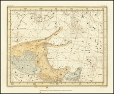
Finely Colored Rare Celestial Hemisphere by Giacomo Brunacci
Fine example of this captivating double hemisphere celestial map by Giacomo Brunacci.
Crafted with precision, the map showcases two hemispheres of the night sky, each filled with an intricate network of constellations and stars. Each star and constellation is elegantly detailed, testament to the astronomical knowledge of the time. This meticulousness extends to the positioning and the relative brightness of the stars, effectively creating a scientific document that serves as a practical tool for astronomers.
The constellations are depicted as mythological figures, animals, and objects, drawing from both Greek and Roman traditions. These beautifully rendered figures imbue the map with a narrative quality, transforming the night sky into a stage for ancient myths and legends.
The map is not just a celestial tableau, but an attempt to bring order and comprehension to the vast expanse of the cosmos. The incorporation of a coordinate grid further underlines the scientific rigour of the period, allowing for the accurate location of celestial bodies. This blending of art and science is a hallmark of celestial cartography, and Brunacci's map epitomizes this tradition.
The map reflects humanity's growing understanding of the universe during the era. The precision of the star placements, the detailed constellation figures, and the comprehensiveness of the celestial bodies depicted all attest to the advancements in astronomical observation and knowledge.
Giacomo Giovanni Rossi (1627-1691) was an Italian engraver and printer. He worked in Rome, the heir to an important printing business founded by his father, Giuseppe de Rossi (1570-1639). Giuseppe began the press in 1633 and Giovanni and his brother, Giandomenico (1619-1653) took it over upon his death. The brothers expanded the business and by the mid-seventeenth century it was the best-known printing house in Rome.
For his maps, Giovanni worked with Giacomo Cantelli da Vignola. They produced the Atlas Mercurio Geografico. The first edition is undated, but the second was issued in 1692, a year after Giovanni’s death. The maps were by Cantelli. The firm also published maps based on those of Nicolas Sanson.
Later, the business passed to Lorenzo Filippo (1682-?). By 1738, the firm was known as Calcografia Camerale, then, from 1870 to 1945, as the Regia Calcografica. Today, the firm is still in business and is called Calcografia Nazionale. It operates as a free museum and offers one of the best collections of prints and plates in the world.
![(Hyginus's Astronomy) De mundi et sphaerae ac utriusque partium declaratione cum planetis et varijs signis historiatis [Clarissimi Hyginii Astronomi]](https://storage.googleapis.com/raremaps/img/small/89256.jpg)
![[ Cygnus ]](https://storage.googleapis.com/raremaps/img/small/83197.jpg)
![[Moon by Domenico Cassini]](https://storage.googleapis.com/raremaps/img/small/82740.jpg)
![Globus Coelestis [Fig: 2]](https://storage.googleapis.com/raremaps/img/small/79601.jpg)