|
||

|

|
|

|
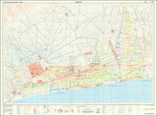
A large detailed town plan of Salalah, Sultanate of Oman, produced by the National Survey Authority of Oman in April 1994, offering a comprehensive view of the city's features and layout at the time.
This map was created using Series 20-01 Orthophoto mapping and aerial photography from November 1991 and March 1993, with field verification conducted in May 1993. As an official publication of the National Survey Authority of Oman, the map provides an authoritative representation of Salalah's urban landscape during the early 1990s. It is important to note that the map does not serve as an authority on the demarcation of municipal or administrative boundaries or areas.
The key provided with the map offers valuable information on a wide range of features, including roads, built-up areas, government buildings, police stations, banks, hotels, post offices, mosques, hospitals, schools, and parks. Additionally, the map identifies natural features such as sand, gravel plains, cliffs, wadis, palm groves, and water sources, as well as various types of vegetation and land usage.
In summary, this 1994 town plan of Salalah, Sultanate of Oman, presents an intricate and informative snapshot of the city's layout and features during that time. The map's detailed key and accurate representation of both man-made and natural elements make it an invaluable resource for those interested in the urban development and history of Salalah and the broader region.
![[Map of the Persian Gulf]](https://storage.googleapis.com/raremaps/img/small/99842.jpg)
![[ Arabian Peninsula ] Sexta Asie Tabula](https://storage.googleapis.com/raremaps/img/small/80372.jpg)