|
||

|

|
|

|
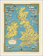
Herman Moll's map of England and Wales
Herman Moll's large format map of the British Isles, colored by counties, is an exceptional work of cartography from the early 18th century. Born around 1654 in Bremen, Moll rose to prominence as one of London's leading mapmakers, gaining recognition for his meticulous detailing and innovative practices.
Moll's map captures the geopolitical landscape of Britain during a crucial period of its history, reflecting the significant changes brought about by the Union Act of 1707. This Act amalgamated the Kingdoms of England and Scotland, leading to a parliamentary restructuring indicated on the map by the marking of towns and boroughs entitled to elect parliamentary members. Moll's map is the first to feature the "Royall Borroughs of North Britain," some of which do not appear on any other maps, exemplifying Moll's commitment to geographical comprehensiveness and accuracy.
The map also incorporates valuable information about Britain's natural resources and infrastructure. It indicates the locations of fisheries and woods in "North Britain," an indication of the critical role these resources played in the economic life of the nation. The inclusion of road systems, derived from John Ogilby's maps, and post towns, as provided by the Postmaster General, highlights the importance of communication and transportation networks in the expanding British Empire. Newly constructed forts, including Bernera, Kilwhnimen, Ruthsun of Badenoch, and Innersnail, are also depicted, signifying the nation's military developments.
Moll's map of the British Isles is more than a geographical representation; it's a testament to the mapmaker's influential connections and collaborations. Moll frequently met with other prominent figures of his time, including explorers, scientists, writers, and publishers, at Jonathan's Coffee House in Change Alley, London. Such interactions likely influenced Moll's work, allowing him to incorporate the latest geographical discoveries and scholarly insights into his maps.
In conclusion, Herman Moll's map of the British Isles is an intricate tapestry of geographical, political, and economic elements of early 18th-century Britain. It stands as an important historical artifact, providing a visual record of the British Isles' evolving landscape during a significant period of its history. Its attention to detail, comprehensive coverage, and integration of various forms of information demonstrate Moll's exceptional contribution to the field of cartography.
Herman Moll (c. 1654-1732) was one of the most important London mapmakers in the first half of the eighteenth century. Moll was probably born in Bremen, Germany, around 1654. He moved to London to escape the Scanian Wars. His earliest work was as an engraver for Moses Pitt on the production of the English Atlas, a failed work which landed Pitt in debtor's prison. Moll also engraved for Sir Jonas Moore, Grenville Collins, John Adair, and the Seller & Price firm. He published his first original maps in the early 1680s and had set up his own shop by the 1690s.
Moll's work quickly helped him become a member of a group which congregated at Jonathan's Coffee House at Number 20 Exchange Alley, Cornhill, where speculators met to trade stock. Moll's circle included the scientist Robert Hooke, the archaeologist William Stuckley, the authors Jonathan Swift and Daniel Defoe, and the intellectually-gifted pirates William Dampier, Woodes Rogers and William Hacke. From these contacts, Moll gained a great deal of privileged information that was included in his maps.
Over the course of his career, he published dozens of geographies, atlases, and histories, not to mention numerous sheet maps. His most famous works are Atlas Geographus, a monthly magazine that ran from 1708 to 1717, and The World Described (1715-54). He also frequently made maps for books, including those of Dampier’s publications and Swift’s Gulliver’s Travels. Moll died in 1732. It is likely that his plates passed to another contemporary, Thomas Bowles, after this death.
![[ New England and Great Britain ] Nova Anglia Gaudenbonis Plurimis De Est Tame Adhuc Angelorum Regin [and] M[ag]na Britannia Dei Matri Cuitu & Beneficiis olim hodieque celebrata](https://storage.googleapis.com/raremaps/img/small/95667.jpg)