|
||

|

|
|

|
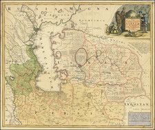
Fine old color example of Pierre Mortier's rare regional of the Podolia region map of Ukraine, based upon Guillaume Beauplan's mapping Ukraine during the 17th century.
At the time the map was created, Ukraine was part of the Polish-Lithuanian Commonwealth and was divided into several administrative regions known as palatinates. One of these palatinates was Podolia, which is the subject of this particular map. Podolia was located in the southwestern part of Ukraine and was bordered by the Dniester River to the south and the Bug River to the north.
The map itself is a detailed and intricately drawn representation of the Podolia region, showing cities, towns, rivers, forests, and other geographical features. The level of detail and accuracy is impressive. The map is also adorned 2 decorative cartouches and illustrations of important figures from the region.
The map shows the territories of several different groups, including the Poles, Ruthenians (also known as Ukrainians), and Tartars.
The maker, Guillaume Beauplan, was a French military engineer and cartographer who lived during the 17th century. Beauplan served as artillery captain for the army of the Crown of the Kingdom of Poland between 1630 and about 1648. He is perhaps best known for his work on the "Description d'Ukraine," a comprehensive survey of the geography, culture, and history of Ukraine. This work included detailed maps of the region.
Beauplan's work on the "Description d'Ukraine" was commissioned by the French ambassador to Poland and was intended to provide detailed information about the region for the benefit of the French government. Beauplan traveled extensively throughout Ukraine, documenting his observations and measurements in meticulous detail.
The present example was originally engraved by Joan Blaeu in about 1670 and later re-issued by Covens & Mortier.
Pierre, or Pieter, Mortier (1661-1711) was a Dutch engraver, son of a French refugee. He was born in Leiden. In 1690 he was granted a privilege to publish French maps in Dutch lands. In 1693 he released the first and accompanying volume of the Neptune Francois. The third followed in 1700. His son, Cornelis (1699-1783), would partner with Johannes Covens I, creating one of the most important map publishing companies of the eighteenth century.
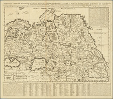
![Carte de la Hongrie et des Pays qui en dependoient autresois dressée sur un grand nombre de memoire. . . 1703 [Map of Hungary and the countries that used to depend on it, previously drawn from a large number of records... 1703.]](https://storage.googleapis.com/raremaps/img/small/93871.jpg)