|
||

|

|
|

|
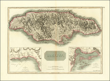
Excellent English map of Jamaica, published by Herman Moll.
The Spanish colonized the island in the early 16th century, bringing with them African slaves to work the land.
In the mid-17th century, the English captured Jamaica from the Spanish, and it became a vital colony for the British Empire. The English established plantations on the island, growing crops such as sugar, tobacco, and coffee. The production of sugar was particularly significant, and it became the dominant agricultural product in Jamaica during the 18th century.
The name "Jamaica" has its origins in the Arawak language, the indigenous people who lived on the island before the arrival of the Europeans. The Arawaks called the island "Xaymaca," which means "land of wood and water." The name was later anglicized to "Jamaica." However, Moll's map references the original name of the island as St. Jago (from Columbus), changed to Jamaica to honor James, the Duke of York.
Moll's map of Jamaica was created in the early 18th century, around the time when sugar production was at its peak. The map shows the precincts or parishes of the island, which were administrative divisions used by the English to govern Jamaica, each with its own local government and a courthouse.
The major parishes on the map include Kingston, Port Royal, St. Andrew, St. Catherine, and Clarendon. These were the most populous parishes, and they were also the major centers of trade and commerce. The map also shows the island's major rivers, mountains, and harbors, which were crucial for transportation and commerce.
The map is significant because it provides a visual representation of the island's economy during the 1720s. The map shows the locations of plantations, as well as the ports where these products were shipped to other parts of the world. The map also shows the location of Fort Charles, which was a key defense point for the English against attacks from other European powers.
Herman Moll (c. 1654-1732) was one of the most important London mapmakers in the first half of the eighteenth century. Moll was probably born in Bremen, Germany, around 1654. He moved to London to escape the Scanian Wars. His earliest work was as an engraver for Moses Pitt on the production of the English Atlas, a failed work which landed Pitt in debtor's prison. Moll also engraved for Sir Jonas Moore, Grenville Collins, John Adair, and the Seller & Price firm. He published his first original maps in the early 1680s and had set up his own shop by the 1690s.
Moll's work quickly helped him become a member of a group which congregated at Jonathan's Coffee House at Number 20 Exchange Alley, Cornhill, where speculators met to trade stock. Moll's circle included the scientist Robert Hooke, the archaeologist William Stuckley, the authors Jonathan Swift and Daniel Defoe, and the intellectually-gifted pirates William Dampier, Woodes Rogers and William Hacke. From these contacts, Moll gained a great deal of privileged information that was included in his maps.
Over the course of his career, he published dozens of geographies, atlases, and histories, not to mention numerous sheet maps. His most famous works are Atlas Geographus, a monthly magazine that ran from 1708 to 1717, and The World Described (1715-54). He also frequently made maps for books, including those of Dampier’s publications and Swift’s Gulliver’s Travels. Moll died in 1732. It is likely that his plates passed to another contemporary, Thomas Bowles, after this death.
![[Jamaica & Cuba] Carte Reduite De L'Isle De La Jamaique pour servir aux Vaisseaux Français . . . 1753](https://storage.googleapis.com/raremaps/img/small/79971.jpg)
![Cuba Insula [with] Hispaniola Insula [with] Ins. Jamaica [with] Ins. S. Ioannis [with] I.S. Margareta [with] Havana portus](https://storage.googleapis.com/raremaps/img/small/95302.jpg)
![Plan des Havres de Port Antonio et de Saint Francois Situes a la Coste du Nord Est de l'Isle de la Jamaique [Map of the Harbors of Port Antonio and Saint Francois Located on the North East Coast of the Island of Jamaica]](https://storage.googleapis.com/raremaps/img/small/81607.jpg)