|
||

|

|
|

|
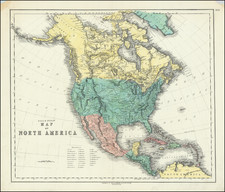
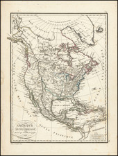
Rare Map of North America with John Law Portrait and Coat of Arms of the Oriental and Occidental French Trading Company
Fascinating map of North America, paying tribute to John Law at the height of the influence of the French Company of the Indies, which profoundly impacted exploration in America and the French economy in the early 18th Century.
This rare map of North America, prominently displays a portrait of Scottish financier John Law, who then held the title "Comte de Tankerville, Conseiller du Roy dans tous ses Conseils, et Contrôleur général des Finances du Royaume de France" (Count of Tankerville, Counselor to the King in all his Councils, and Controller General of Finances of the Kingdom of France), testimony to Law's influential position within the French monarchy. The map, with its elaborate title translating to "General Map of North America, especially the French Colonies therein, with the Coat of Arms and Sign of the Oriental and Occidental French Trading Company," is a compelling representation of the Mississippi Bubble era and its profound effects on French exploration in America and the French economy.
John Law, featured in the bottom left corner of the map, was the architect of the economic policy that resulted in the Mississippi Bubble, one of the most notorious financial crashes in history. Law's ambitious economic strategy involved the formation of a state-controlled trading monopoly, the Compagnie des Indes (Company of the Indies), and the introduction of paper money, which was expected to be backed by the vast wealth of the French Louisiana territory in North America.
The map embodies the zenith of French exploration and territorial expansion into North America. The Mississippi River, prominently (and quite inaccurately) displayed, stands as both the symbolic and actual center of this economic venture. The river and its valley were seen as a potential treasure trove, a source of endless future wealth, fueling a surge of investment in the Compagnie des Indes and dramatically inflating its stock value.
The emblem of the Oriental and Occidental French Trading Company, another facet of Law's economic plan, is also depicted on the map. This emblem underscores the vast influence of the company and the grand aspirations of French commercial pursuits during this period. It symbolizes an era when economic prosperity seemed achievable, with the riches of the New World just waiting to be seized.
After a period or rampant speculation, the Mississippi Bubble eventually burst, triggering a significant economic disaster. The anticipated wealth of the Mississippi Valley proved to be largely a myth. As investors became aware of this, faith in the Compagnie des Indes collapsed, leading to a swift decline in the company's stocks and a subsequent financial crisis. This crash had a profound impact on the French economy, resulting in widespread bankruptcy and severely damaging the reputation of the monarchy and the emerging system of paper money.
States of the Map
McLaughlin (almost certainly incorrectly so) dates the map as 1757 and notes 3 states of the map, as follows:
- State 1: French title at top (Carte Generale De L'Amerique Septentrionale et principalement des Colonies Francoises qui s'y trouvent avec les Armes de la Compagnie Francoise des Indes Orientales et Occidentales). Engraver listed as Georg Christoph Kilian
- State 2: Title in German: General Charte von dem Mitternächt AMERICA und sonderlich denen darin befindliche Französ Colonien mit dem Wappen und Zeichen der Orientalischen u. Occidentalischen Französische Handels Compagnie at top left, with the engraver still listed as Kilian .
- State 3: Identical with State 2, except with different engraver's name: Gabriel Bodenehr sculps. et excudit Aug. Vind.
To this we add a fourth state (which we believe to be the real State 1) and suggest that McLaughlin's state 1 may not exist (see below).
- State 4: French title at top (Carte Generale De L'Amerique Septentrionale et principalement des Colonies Francoises qui s'y trouvent avec les Armes de la Compagnie Francoise des Indes Orientales et Occidentales). Engraver listed as Gabriel Bodenehr.
It would seem unlikely that McLaughlin's order of states is correct. Georg Christoph Kilian (1709-1781) was much younger than Gabriel Bodenehr and active much later, and it would have been very unlikely that he would have published an edition of the map prior to Gabriel Bodenehr (1673-1765). The example illustrated by McLaughlin on line in the Stanford collection has the name of the maker cut off and the title in French. We note that in the Library of Congress, in a work entitled Curioses Staats und Kriegs Theatrum . . ., Philips (#2814) dates this state of the map as being from 1717, and we note that the vast majority of Bodenehr's maps were published between 1704 and circa 1715.
As such, we propose that the following:
- State 1: French title at top (Carte Generale De L'Amerique Septentrionale et principalement des Colonies Francoises qui s'y trouvent avec les Armes de la Compagnie Francoise des Indes Orientales et Occidentales). Engraver listed as Gabriel Bodenehr.
- State 2: Title in German: General Charte von dem Mitternächt AMERICA und sonderlich denen darin befindliche Französ Colonien mit dem Wappen und Zeichen der Orientalischen u. Occidentalischen Französische Handels Compagnie at to left, with the engraver still listed as Bodenehr.
- State 3: Identical with State 2, except with different engraver's name: Georg Christoph Kilian
- State 4: McLaughlin's state 1 -- possibly apochryphal (McLaughlin having erroneously assumed that his example was engraved by Kilian, as map was trimmed below the neatline). We note that the example at the University of Michigan is also cut below the neatline, but the Bodenehr's name can be detected.
Rarity
This is the second time we have had the map in the past 30 years.
Gabriel Bodenehr the Elder (ca. 1673-ca. 1766) was a German engraver and publisher. He originated views of many German cities, for example the first plan of Passau (1710), and is best known for his Atlas Curieux (1704). His son, Gabriel the Younger (1705-1779), followed his father in his profession and was also a well-known engraver.