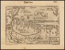
|
||

|

|
|

|
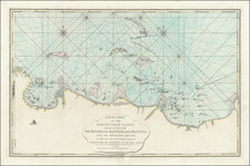
This is an intricate 1780 engraved plan of Batavia by A. Van Krevelt, published by P. Conradi in Amsterdam and V. Van der Plaats in Harlingen. Batavia, now known as Jakarta, was the capital of the Dutch East Indies and an important hub of trade during the 18th century, making this plan a valuable record of Dutch colonial history.
The plan is marked by its precise detailing and utilization of a grid system to denote the city's districts, labeled as A, B, C, and so forth. This system of urban organization reflects the Dutch colonial authorities' efforts to impose order and control over the urban environment of Batavia. The plan, drawn up in 1770 under the governance of P.A. van der Parra, was produced by decree, indicating its status as an official representation of the city.
The map's vertical orientation, a characteristic feature of many Dutch city plans, enhances the visual impact of Batavia's urban layout. The city's castle - the 'Kasteel Batavia' - is prominently featured, serving as a reminder of the military power underpinning Dutch colonial rule. The plan's meticulous attention to streets, buildings, and city sections provide a comprehensive view of Batavia as it was in the late 18th century.
The engraved plan of Batavia by Van Krevelt is more than a geographic representation; it is a manifestation of the colonial imagination, where the order, control, and categorization imposed on the physical space mirror the structures of colonial rule. Its historical significance is further underlined by the fact that Batavia has since evolved into Jakarta, the capital of Indonesia, making the plan a testament to the city's past as a Dutch colonial stronghold.