


|
||

|

|
|

|
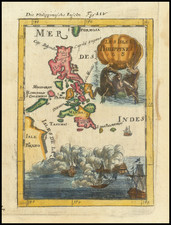
Philippe Vandermaelen's expansive six-sheet map of the Philippines and surrounding areas is a monumental work of cartography. It stands as one of the earliest and most detailed representations of the region on such a large scale, offering a unique and profound insight into the geographical characteristics of the Philippine archipelago during the era.
This set of maps stands out for their unparalleled detail, with various islands, towns, rivers, mountains, and other geographical features meticulously marked. Each sheet is a testament to Vandermaelen's painstaking precision, offering a wealth of information that contributes to the viewer's understanding of the region's topography.
Perhaps the most striking characteristic of these maps is their scale, with the entire set designed to combine as globe gores to form a gigantic globe of 25 feet in diameter. This scale is impressive, dwarfing the notable 395 centimeter (12.95 feet) globes created by Vincenzo Coronelli and held by the Bibliotheque Nationale de France.
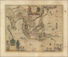
The map collection forms part of Vandermaelen's pioneering six-volume atlas, a monumental achievement in the field of cartography for two key reasons. Firstly, it represents the inaugural atlas mapping of the world on a uniform scale. This accomplishment provided an unprecedented level of consistency in representing global geography, setting a standard for future cartographical endeavors.
Secondly, Vandermaelen's atlas is the first known to be printed using lithography. This innovative technique, which uses a process of chemical repulsion to transfer images onto paper, allowed for the production of maps with greater detail and precision than previous printing methods.
The note at the right describing the Philippine Islands translates as follows:
In the Mariana Archipelago, only the islands of Guam, Rota, and Tinian are inhabited; all the others are completely deserted. The island of Guam, which is 40 leagues in circumference, is entirely volcanic, composed of reddish burnt terrain mountains. There are thirty-five rivers on it, some of which roll specks of iron and copper. The main ones are Tarafofo, Ilig, & Pago. Few countries are more fertile and neglected than these islands; the richness and variety of the vegetation are remarkable. The trees are magnificent, and the fruits and vegetables delicious. Indigo and cotton plants are very common on the Mariana islands, but no use is made of them. On the other hand, a lot of tobacco is grown. This colony is the only one of those that belong to Spain where tobacco can be freely cultivated, as elsewhere it is a government monopoly.
The inhabitants are generally gentle and trusting towards foreigners, but they like to be dealt with familiarly; you cannot give them greater pleasure than to address them informally. This expectation may well be aimed at more conveniently satisfying their dominant passion, which is to appropriate the property of others. Magellan himself fell victim to his good faith here, so he gave the Mariana Islands the name Ladrones (Islands of Thieves). On the island of Guam, the dress of men and women is, with few modifications, like that of the people of some provinces of Spain. Instead of the Mantilla, women place a handkerchief on their forehead, which they let flow over their shoulders. The hair is tied very low and behind. The corset faintly veils the chest and rarely covers the loins. The skirts are generally very long. They sometimes wear men's hats. Men almost always wear a shirt over pants that are very short and rarely go past the knee. The complexion of both men and women is dark yellow; they generally have teeth ruined by the use of betel and lime, which they season it with; everyone smokes, and you see, in almost every house, children from four to five years old, cigar in mouth. Among the women, there are some who never stray from their duties, among which they understand very well fidelity towards their husbands: but this practice does not make law; the number of those who free themselves from it is infinitely greater than the number of those who submit to it. On the island of Rota, the men are, so to speak, completely naked, since they only wear pants on Sundays, the women place a handkerchief in front of them held by a rope, around which they make it turn according to whether you are in front of them or behind; the rest of the body is absolutely naked. Their forms are very beautiful, their gait is easy, their chest is high and well separated; their feet are small, their legs well-shaped, their hair, a beautiful black, floating over their loins and shoulders.
These islanders love music. Their tunes are languid and harmonious. They have two or three kinds of dances, among others one called the dance of Montezuma, but this exercise is only in use among children to the sound of the mandolin or the voice. In Agana, on the island of Guam, a royal college and several secondary schools have been established, where they learn to read and sing; this is what all teaching consists of, and yet there is no country in the world, where sons have more respect for the authors of their days. The people are very superstitious. There is no effect, however small, to which they do not recognize a great cause. All their traditions speak only of extraordinary phenomena, of which their country would have been the theater. Also, no nation in the world adds more faith to the relations of miracles than the one that inhabits the Marianas today.
A vigorous leprosy reigns in these islands among both sexes. This disease usually deprives those affected of their tongue, or some of their limbs. It is contagious. There are some isolated houses where lepers are kept.
Apart from the Vampire bat species, the only native mammal of this archipelago is the rat, which is extremely abundant. The Spaniards have introduced European domestic animals, the Guanaco from Peru, and the Deer from the Philippines. Several of these animals have become wild. There are various terrestrial birds among others, falcons. Among the amphibians are the Iguana and the large sea turtle, and among the zoophytes some species of Holothuria which, under the name of Trepang, Sea Cucumber, and Balate, form an important branch of trade with China.
The population of the Mariana Archipelago, all confined to the islands of Guam, Rota, and Tinian, does not exceed 6000 souls, whereas, according to ancient travelers, it was 44,000. There is a mixture of Spanish customs with those of the natives who, although forced to abjure certain ancient customs, have nevertheless adopted from their conquerors those that in some way relate to their national spirit.
Philippe Marie Vandermaelen (1795-1869) was a Belgian cartographer and geographer known for his pioneering use of technology and his leadership in establishing the important Establissement geographique de Bruxelles. Born in Brussels, Philippe was obsessed with maps from a young age. He taught himself mathematics, astronomy, and mapmaking and plotted the battles of the Napoleonic wars avidly. He took over his father’s soapmaking business briefly in 1816, but then turned it over to his brother in favor of cartography.
From 1825 to 1827, he released his first atlas, the Atlas universal, which was well received. It was sold in forty installments of ten maps each, with 810 subscribers listed. The atlas contained 387 maps in six volumes at a uniform scale of 1:1.6 million. The maps were intended to be joined and together would create a globe 7.755 meters wide. It was the first atlas to show the entire world on a large uniform scale and was the first atlas produced using lithography. This project served as Vandermaelen’s gateway into intellectual life, gaining him membership in the Royal Academy of Sciences and Belles-Lettres of Brussels (1829).
In 1830, Vandermaelen inherited a laundry from his parents which he converted into the Establissement geographique de Bruxelles, or the Brussels Geographical Establishment. His brother, Jean-Francois, also established a botanical garden on the site. The Establishment had its own lithographic press, one of the first to use the technology for cartography and the first in Belgium. They produced textbooks, surveys, and especially maps of Brussels to be used for urban planning. The complex also housed schools, an ethnographic museum, and a library open to the public. Vandermaelen was passionate about geographic education and saw the Establishment as an open place where people could learn about the world.
In 1836, he was knighted for his services to geography and the intellectual community of Belgium. He died at age 73 in Molenbeek-Saint-Jean, near the Geographical Establishment that he founded. After Vandermaelen’s death, the Geographical Establishment declined, closing its doors in 1880. The extraordinary collection they had amassed passed to several institutions, most importantly the Royal Library of Belgium.
![(First state!) [ Southeast Asia ] Tabula Asiae XI](https://storage.googleapis.com/raremaps/img/small/94616.jpg)

![Goldene Pagode [Shwedagon Pagoda, Yangon]](https://storage.googleapis.com/raremaps/img/small/90252.jpg)