|
||

|

|
|

|
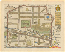
A rare Czech language edition of Heinrich Bunting's imaginative and stylized plan of the walled City of Jerusalem, featuring key elements such as King David and Solomon's temples, olive trees, and more. This woodcut, published in Prague in 1592, showcases a creative interpretation of the Holy City's landscape.
This artistic rendition of Jerusalem reflects the significance of the city in the religious imagination of the late 16th century. The map highlights important historical and biblical landmarks, such as the temples of King David and Solomon, emphasizing their centrality to the city's religious heritage. The inclusion of olive trees, which hold both symbolic and historical importance in the context of Jerusalem, further demonstrates the mapmaker's desire to capture the essence of the Holy City.
The "Konterfekt Swatého Města Geruzaléma" is a testament to the cartographic creativity of its time, as well as the enduring fascination with Jerusalem as a focal point of religious history. The stylized representation not only offers a visually compelling perspective on the city but also provides valuable insights into the way it was perceived and understood by Europeans during the late 16th century.
Henrich Bunting was a Protestant theologian and teacher born in Hanover, in what is now Germany. He attended the University of Wittenberg and graduated in 1569. He then began work as a preacher but caused some controversy with his teachings; he was dismissed from appointments in both Lemgo and Goslar.
He is best known today for his book, Itinerarium Sacrae Scripturae (Travel book through Holy Scripture), a travel collection and commentary of the geography of the Bible. The book provided the most complete summary of biblical geography then available and described the Holy Land by following the travels of various notable people from the Old and New Testaments. First published in Madgeburg in 1581, Itinerarium Sacrae Scripturae was a very popular book for the time. Over 60 editions were published between 1581 and 1757.
A particularly notable feature of the book were its many woodcut maps, many of them showing unique depictions of geographic features and continents. In addition to the conventional maps, the book also contained three figurative maps; the world depicted using a cloverleaf design (thought to possibly represent the Trinity with Jerusalem in the center), Europe in the form of a crowned and robed woman, and Asia as the winged horse Pegasus.
![[Jerusalem] Waerachtige beschryvinge vande wydvermaerde Conincklicke Hooft Stadt Ierusalem . . .](https://storage.googleapis.com/raremaps/img/small/96558.jpg)