|
||

|

|
|

|
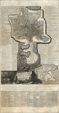
Fine example of Piranesi's remarkable modern map of Rome, dedicated to Pope Clement XIV.
First issued in 1774, the map is oriented with south at the top. Piranesi's remarkable large format map shows the modern city of Rome within Aurelian Walls, together with an extension showing the territory to the north, between Porto del Popolo and Ponte Milvio and including the Campus Martius area.
At the lower right corner is a smaller map of the city, focused on the location the principal antiquities of Rome, corresponding to the numbered key. Around these Piranesi arranged a detailed index listing the monuments according to their assigned number and referring to relevant passages in his major publications, including the Antichita Romane, Della Magnificenza and Campo Marzio. Over 400 locations shown.
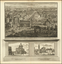
The plan is illustrated as if engraved on stone, in the style employed by Piranesi in his Antichità Romane, as an homage to the ancient Forma Urbis Romanae, the massive marble map commissioned under Septimius Severus (ruled A.D. 193-211).

![Veduta di Piazza Navona sopra le ravine del Circo Agonale [View of the Piazza Navona above the Ruins of the Circus Agonalis; Circus of Domitian]](https://storage.googleapis.com/raremaps/img/small/93192.jpg)