


|
||

|

|
|

|
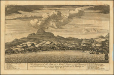
Rare early map of Martinique, published in Paris at an important early moment in its French colonial history.
The map illustrates the mountainous terrain of the island, numerous anchorages, a Jesuit Mission, Fort Pierre and the house of Governor Parquet are shown on the southwest side of the island, with a number of Carbet noted on the northeast side.
Created by François de La Pointe and published by Thomas Jolly in 1667, the map offers a valuable insight into the historical context of Martinique and its connection to French colonial ambitions in the West Indies. The island was governed by Mr. de Parquet at the time, and its representation in Jean Baptiste Du Tertre's "Histoire generale des Antilles habitées par les Francois ... " underscores the importance of the French presence in the region.
Du Tertre was sent by the Dominicans as a missionary to the Antilles, where he stayed from 1640 until 1658. His book was described by Sabin as "One of the most valuable [works] we possess on the West Indies." The work is scarce, the final volume, issued in 1671 with additional maps, is very quite rare.
Coronelli copied this map in the 1680s and early 1690s.
Rarity
This is the first time we have offered this map for sale.
![Martinico [and] Dominica](https://storage.googleapis.com/raremaps/img/small/85250.jpg)
![[Martinique] Het Westindisch Eiland Martenique Volgens de nieuwste Waar neemingen in Kaart gebragt…](https://storage.googleapis.com/raremaps/img/small/85252.jpg)
![[ Charleston, Boston, New York, St. Augustine, Bahamas, etc ] Particular Draughts of some of the Principal Towns and Harbours belonging to the English French and Spanish in America and the West Indies.](https://storage.googleapis.com/raremaps/img/small/102804.jpg)