|
||

|

|
|

|
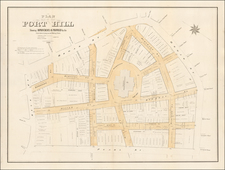
Water Mill Map From the Heart of America's Early Industrial Revolution.
Finely drawn map of the area around the Saunders Cotton Mills, surveyed and drawn by Arthur Moore, Civil Engineer.
Saunders Cotton Mill was located in Grafton, Massachusetts in the late 19th Century. The Mill is shown at the center right on the Blackstone River, with a tail race and Pond to the west, noting the location of the pond dam. The Mill complex is shown, along with roads and a number of outlying buildings, many of which housed employees of the mill. Further out, the lands of other property owners are noted, along with a School House, House, Barns and the location of the Providence & Worceser Railroad, railroad bridge across the river and Saundersville depot.
Further north, the Fitzpatrick Grist Mill is shown on a Pond off the Gull River, with details on the pond dam.
Esek Saunders was the owner Saunders Cotton Mills. Saundersville is a mill village in the town of Grafton, MA and, as was a common practice, as a village developed it was named after the mill. The area is now more commonly known as South Grafton.
![[ Revolutionary War Boston ] Carte Particuliere Du Havre De Boston . . . 1780](https://storage.googleapis.com/raremaps/img/small/61227.jpg)