|
||

|

|
|

|
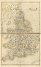
Gardner's map of England and Wales is a valuable historical artifact that provides insights into the state of Britain's transportation and socio-economic infrastructure during the early 19th century. This map, including the southern part of Scotland, is comprehensive and detailed, covering various aspects such as mail and turnpike roads, cities, market towns, gentlemen's castles, polling places, canals, railways, and tunnels.
At the time of its creation, England and Wales were undergoing rapid transformations spurred by the Industrial Revolution. The introduction of new roads, turnpikes, canals, and railways had altered the physical landscape, leading to the need for a 'new and improved' map. Thus, this map represented a need to record and understand the evolving infrastructure and geography.
The map distinguishes between mail and turnpike roads. The mail roads, primarily used for transporting mail, offer an interesting glance into the communication networks of the era, while the turnpike roads, toll roads built and maintained by private entities, shed light on the commercial routes that facilitated trade and transport. The depiction of both direct and cross roads on the map highlights the extent of connectivity and accessibility during this period.
The inclusion of market towns indicates the economic hubs of the era, as these were the centers of trade and commerce. The presence of gentlemen's castles, often the residences of the aristocracy, indicates areas of wealth and political influence, reflecting the social hierarchy of the time.
The map also marked polling places, providing insight into the political landscape of the early 19th century. During a time when voting rights were limited, the locations of these polling places could also hint at the areas with a higher concentration of eligible voters.
Canals and railways are also included, illustrating the significant advancements in transport and logistics. The advent of railways during the early 19th century signaled a shift towards faster, more efficient means of transporting goods and people. Canals, too, played an essential role in trade and travel, often linking towns, cities, and industrial centers.
![[ London ] Londinum Feracis: Ang. Met.](https://storage.googleapis.com/raremaps/img/small/74642.jpg)
![[Saxon Britain] Britannia Saxonica](https://storage.googleapis.com/raremaps/img/small/85220.jpg)