|
||

|

|
|

|
Drawn To Inform Alejandro Malaspina During The Nootka Convention Negotiations
The Earliest Printed Map To Show The Results of the 1788 Martinez Expedition
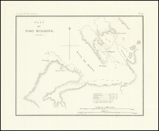
Fine example of this virtually unknown map of the West Coast of North America, from the Aleutian Islands to Acapulco, being the first printing of the map prepared by Juan Francisco de la Bodega y Quadra for Alejandro Malaspina in conjunction with the former's appointment as Spanish commissioner to negotiate and administer the implementation of the Nootka Conventions.
After a successful career as an explorer of the Spanish Pacific Northwest in the 1770s, Bodega y Quadra spent the 1780s first on the Pacific Coast of South America and later in Cuba, during which time he was knighted in April 1788. Thereafter, he was appointed commandant of the Naval Department of San Blas, arriving at his new posting in the midst of the Nootka Crisis, following the capture of several British ships by Esteban José Martínez Fernández y Martínez de la Sierra and Gonzalo López de Haro during the 1788 Martinez Expedition (see below). Following the dispatch of an expedition to Nootka in April 1790 to reinforce Nootka and construct a fort, Bodega y Quadra dispatched another surveying party in preparation for negotiations with the British to address the territorial claims of Britain and Spain, which ultimately resulted in the three Nootka Conventions of 1790, 1783 and 1794.
As noted by Wagner, amid the crisis, on February 4, 1791, Bodega y Quadra dispatched the San Carlos to Nootka with instructions to Francisco de Eliza y Reventa (commandant of the Spanish post at Nootka) to undertake further surveying south to the the mouth of the Columbia River. On March 12, Bodega y Quadra sent supplemental instructions via the frigate Aranzazu, instructing Eliza to "examine the entrance between 54° and 55° and the Rio de Martin de Aguilar, in order to further enrich the general plan of the coast." Wagner notes that with the letter, "Bodega enclosed a [hand drawn] general plan of the coast [Wagner 772] which he had just made to give to Alejandro Malaspina, who was then proceeding to Alaska."
The present map is the earliest printed version of Wagner 772. The map's title translation gives an excellent overview of its creation and coverage:
General Map of What Has Been Discovered and Examined to Date by the Spaniards on the Northern Coast of California [Cartographic Material] / formed under sound knowledge in accordance with the Meridian of San Blas which is 88º 15' W of Tenerife by Don Juan Francisco de la Bodega y Cuadra of the Order of Santiago, Captain of the Ship of the Royal Navy and Commander of the Department, Year of 1791.
In Wagner's chapter on the Martinez Expedition of 1788:
The data on the maps [from the Martinez Expedition] were no doubt transcribed by Bodega to his map of 1791 . . . . On this the number of names taken from the text or maps of Cook's voyage, frequently in a French or corrupted form, is particularly noticeable. The fact is that the commanders were in a large measure guided by Cook's maps. A peculiarity of Bodega's map is the appearance west of Unalaska of a number of the eastern Aleutian group extending over some eight degrees of longitude. It is certain, of course, that the expedition saw none of these except possibly the one adjacent to Unalaska. Nevertheless, all but two have Spanish names. The only possible inference in that Martinez obtained these from two Russian maps which he brought back and that either he or Bodega put Spanish names on them. The identification of the various places named, even with the assistance of Bodega's map, is not always very easy. It has not been possible to identify satisfactorily even the anchorage at Unalaska Island. The obvious thing for Martinez to do was to anchor in the same port as that in which Cook had anchored on the north end of the island, but it seems that he anchored in Unalaska Bay, on the northwest side, as it is probable that the Russians had a settlement in some part of it. Dutch Harbor is at the bottom of this bay and this probably is on or near the site of the old Russian establishment.
Wagner's catalog entry no. 772 describes a manuscript map under the same title, with dimensions: 91.5 x 61.5 cm, being the Woodbury Lowry example (entry no. 691). The original in Museo Naval (erstwhile Depósito Hydrográfico), Madrid, Atlas II, No. 12.
Includes the following inset maps:
- "Plano del Puerto de los Remedios / levantado por el Teniente de fragata D. Juan Fraco. de la Bodega y Cuadra y el piloto D. Fco. Maurelle en 1775"
- "Plano de la Entrada o Puerto de Bucarelli / descubierto y levantado por el Teniente de fragata D. Juan Fco. de la Bodega y Cuadra y el Piloto Fco. Maurelle en 1775"
- "Plano del Puerto de la Bodega / descubierto por D. Juan Franco de la Bodega y Cuadra en 1775"
Dating The Map
The publication date of the map is uncertain. The Spanish National Library lists the map date as unknown.
The paper and printing method suggest a printing date in the first half of the 19th Century.
Rarity
The map is extremely rare.
We note only the example in the National Library of Spain.
The map is listed as having been in the Library of Alexander Von Humboldt (p. 180).
In Boletin de la Sociedad Geografica de Madrid (Volume 12, 1882, p. 159), a reference to the original manuscript map notes that the the riginal, in the Deposito Hidrografico, where several other maps of recognition made by Bodega y Quarda are kept, either alone or in collaboration with the ship lieutenants D. Ignacio Arteaga and D. Bruno de Hezeta, and of the pilots Mr. Juan Martínez y Zayas and Mr. Francisco Mourelle.
Martinez Expedition
The 1788 expedition, under the command of Esteban José Martínez Fernández y Martínez de la Sierra and Gonzalo López de Haro, embarked on a critical mission from the port of San Blas. Their mandate was to assess Russian activities along the northern Pacific coast, specifically regarding the expansionist intents in the Nutka region, as authorized by Empress Catherine II. The two vessels, the frigate Nuestra Señora del Rosario, also known as La Princesa, and the packet boat San Carlos, also known as El Filipino, left port on March 8th, 1788, with the pilot José María Narváez among the crew.
Their voyage led them to the Southwestern coast of Alaska by May, and by June, they had reached Kodiak Island. Here, they encountered Eustrati Ivanovich Delárov, a Russian supervisor of Macedonian descent, and confirmed the presence of Russian trading posts. The Spaniards proceeded to Unalaska Island, where they received confirmation of Russian plans to occupy Nutka.
The documentation of the expedition includes detailed accounts, such as an anonymous report from aboard El Filipino, describing the distribution of warm clothing to the crew and the challenging navigation conditions. Esteban Martínez, in his observations, noted various geographical features and named them, such as Floridablanca and Carmen, while navigating through the areas previously explored by Captain Cook.
Gonzalo López de Haro's notes reflect the challenges and disagreements about their precise location, illustrating the difficulty of navigation at the time. Despite these challenges and internal conflicts, the expedition underscored the need for a Spanish presence to counteract the Russian and British activities, as evidenced by the British establishment at Yuquot in Nutka's Friendly Cove.
Following the expedition, Viceroy Manuel Antonio Flores commissioned Martínez de la Sierra to establish a permanent settlement at Nutka Bay. In February 1789, Martínez set sail with Narváez and López de Haro to Nutka Bay, where he founded the fort of San Miguel, armed with 10 cannons, and constructed barracks.
Upon arrival on May 5th, Martínez took formal possession of the territory. There, he encountered several foreign merchant ships. Two Bostonian ships were allowed to leave, while the Portuguese-flagged, British-crewed Iphigenia Nubiana was seized. The subsequent arrival of the British ship Argonaut, commanded by Captain James Colnett, led to further confrontations. Martínez, asserting Spanish sovereignty claimed since Juan Pérez's expedition in 1774, detained Colnett and seized his vessel, as well as the Royal Princess and Northwest America that followed.
The captured ships were sent to San Blas, but Martínez's actions, marked by a lack of diplomacy, tarnished his reputation. His decisions at Nutka would later contribute to the diplomatic tensions culminating in the Nootka Crisis, a significant event in the geopolitical history of the Pacific Northwest.
Juan Francisco de la Bodega y Quadra was a notable figure in late 18th-century maritime exploration. Born in Lima, Peru, in 1744 to a Spanish naval family, he joined the Spanish Navy in 1760 and quickly distinguished himself as a skilled navigator and cartographer.
Bodega y Quadra's most significant contributions were in the exploration of the Pacific Northwest coast of North America. In 1775, he participated in expeditions that reached as far north as Alaska. He is perhaps best known for his explorations in 1779, where he charted the coastline of California, including the discovery of Bodega Bay, named in his honor.
In 1790, during the Nootka Controversy between Spain and Britain over territorial claims in the Pacific Northwest, Bodega y Quadra was appointed Spanish commissioner. He was tasked with negotiating with British Captain George Vancouver to resolve territorial disputes on Vancouver Island and the surrounding areas. His diplomatic skills were instrumental in the peaceful resolution of these tensions, leading to the Nootka Convention, which eased hostilities and outlined respective territorial rights.
Bodega y Quadra's legacy extends beyond his exploration achievements. He was known for his fair treatment of indigenous peoples and his efforts to understand and document their cultures. His detailed maps and navigational charts were invaluable to future explorers and remain a testament to his skill and dedication.
He passed away in 1794 in Mexico, leaving behind a legacy as one of the most important figures in the Spanish exploration of the Pacific Northwest. His contributions to navigation, diplomacy, and intercultural relations were significant in shaping the history of the region.
![(Stockton, California) [Manuscript Railroad Map of Stockton, California, on three sheets; Mormon Channel (Slough), Stockton Electric Railway; heavily annotated]](https://storage.googleapis.com/raremaps/img/small/96266.jpg)