|
||

|

|
|

|
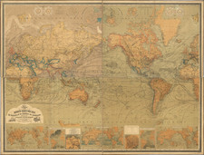
Large, folding political map of the world with a news digest for the week of August 27 to September 2, 1943, detailing notable events.
An inset map shows Zealand and Landskrona on the other side of the Oresund Strait. A second inset map shows the battle line west of Salamaua in New Guinea. A set of four maps shades the changing battlefronts in Europe from 1940 to 1943.
World News of the Week (1939-1963), published by News Map of the Week (1937-1963), a division of the W. M. Welch Scientific Company (now the Sargent-Welch Scientific Company), was a hebdomadal publication of news maps primarily for use in secondary schools, with briefs of the most pertinent events of the preceding week. Leroy Kreutzig, a Chicago-area journalist, wrote copy for the publication for much of its existence; he also occasionally made the inset maps. During World War II, he also helped make maps used by American troops. Although war dominates the stories, other domestic and international stories are also covered. Photographs, infographics, cartoons, and phonetic spellings of names add to the educational value of the maps.
![[Terrestrial Globe Gore] and [Celestial Globe Gore]](https://storage.googleapis.com/raremaps/img/small/91969.jpg)
![[ WWI Anti-German Propaganda ] Le Plan Pangermaniste](https://storage.googleapis.com/raremaps/img/small/63622.jpg)
![[From the Library of Captain Louis Freycinet] Carte Hydrographique Des Partes Connues De La Terre Dressee sur la Projection de Mercator, Poar C.LO. Gressier , Ingenieur Hydrographe de la Marine . . . 1835 (with extensive manuscript annotations)](https://storage.googleapis.com/raremaps/img/small/58604.jpg)