|
||

|

|
|

|
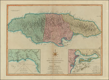
Detailed map of Jamaica from the April 1762 edition of London Magazine.
This small map of Jamaica shows the island as a British colony with several established settlements, ports, and plantations scattered across its terrain. The map may also highlight the island's rugged terrain and natural resources, including mountains, rivers, and forests.
Jamaica island was first claimed by the Spanish in 1494, but it was not until 1655 that the British captured it and made it a permanent colony. Over the next few decades, the British established large-scale sugar plantations and brought in African slaves to work them, leading to a sharp increase in the island's wealth and prosperity.
Throughout the 18th century, Jamaica remained a crucial hub of the British Atlantic economy, exporting sugar, rum, and other commodities to Europe and North America. However, the island's economy was heavily dependent on slave labor, and there were numerous uprisings and rebellions by enslaved people seeking their freedom. One of the most significant of these was the 1760 Tacky's Rebellion, which involved thousands of enslaved people and lasted for several months before being brutally crushed by the British.
In the years following Tacky's Rebellion, the British government became increasingly concerned about the possibility of further uprisings and the impact they could have on the island's lucrative sugar industry. To try to prevent this, they passed a series of laws and policies aimed at strengthening the control of the white ruling class over the island's enslaved population. These included the 1765 Jamaica Act, which gave white landowners even more power over their slaves, and the 1783 Zong massacre, in which enslaved people were thrown overboard from a slave ship in order to claim insurance money.
The Gentleman’s Magazine was a British publication that helped to normalize the use of maps in support of articles and features. It was founded in 1731 by the prominent London publisher Edward Cave, a pioneer in periodical journalism. The magazine continued in print for nearly two centuries, shuttering production in 1922.
This was the publication which first used the word “magazine”, from the French for storehouse. Cave wanted to create a storehouse of knowledge and he employed some of London’s best writers to fill his pages: Samuel Johnson gained his first regular employment by writing for the Gentleman’s Magazine. Other famous contributors included Jonathan Swift.
The publication covered a broad range of topics, from literature to politics, and, from 1739, frequently used maps as illustrations. The first map they printed was a woodcut of Crimea; the second was a fold-out map of Ukraine by Emanuel Bowen. Maps were used to show battle lines, to chronicle voyages, and to educate about areas with which Britain traded. Certain geographers, like Thomas Jefferys, contributed several maps to the publication.
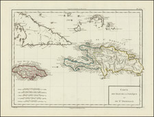
![[Jamaica & Cuba] Carte Reduite De L'Isle De La Jamaique pour servir aux Vaisseaux Français . . . 1753](https://storage.googleapis.com/raremaps/img/small/79971.jpg)