


|
||

|

|
|

|
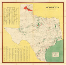
Very rare and early oil map covering oilfields in Texas and adjoining states.
The map was probably produced in a minimal print run for the specific purpose of illustrating the holdings of a few short-lived oil companies during the early 1920s oil boom. The named companies show up in industry periodicals from the last 1910s to the early 1920s, corresponding with an explosion in interest in oil exploration and exploitation sweeping Texas and the nation at the time.
The map names the important early Texas oilfields, including Spindletop, High Island, Humble, Sour Lake, etc.
The map covers Dallas and Fort Worth, Houston, Austin, and San Antonio. The map leaves out West Texas and the Panhandle, which were later to the party in terms of oil exploration, but still, at this time, had substantial oilfields. This could point to an earlier date than the one we purpose. However, the more confined scope of the map likely just reflects the specific areas owned by the named companies.
Rarity
This is apparently the only extant example of the map; we find no records in OCLC nor in RBH.
![[Austins Colony] Mexico & Guatemala](https://storage.googleapis.com/raremaps/img/small/94054.jpg)


![[Wisconsin] General Map of the Lead Region Showing the Distribution of the Lodes . . . By James Wilson, Jr. 1880](https://storage.googleapis.com/raremaps/img/small/59314.jpg)