|
||

|

|
|

|
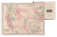
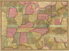
Decorative and highly detailed railroad map of the United States, one of the most interesting of the period.
The map extends west to Texas and Nebraska, with a large inset showing the routes of the Union Pacific To California, the only Transcontinental connection to the west then in existence. Marvelous steam engine vignette.
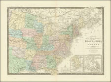
The map was issued must months after the completion of the first transcontinental railroad, a monumental feat of engineering that connected the Atlantic and Pacific coasts for the first time in history. The transcontinental railroad was the culmination of years of political wrangling, technological innovation, and financial investment. It was also a symbol of the country's manifest destiny, a belief that the United States was destined to expand westward and dominate the continent.
The transcontinental railroad consisted of two main lines that met at Promontory Point, Utah, on May 10, 1869. The first line was the Union Pacific, which began in Omaha, Nebraska, and headed westward across the Great Plains and the Rocky Mountains. The second line was the Central Pacific, which began in Sacramento, California, and headed eastward across the Sierra Nevada and the Great Basin. The two lines were built by different companies, using different technologies and labor forces, but they were united by a common goal: to create a continuous rail link between the two coasts.
The completion of the transcontinental railroad had a profound impact on the United States. It transformed the country's economy by facilitating the movement of people, goods, and capital across vast distances. It opened up new markets for agricultural and industrial products and spurred the growth of cities and towns along its route. It also enabled faster and more efficient communication and transportation, which helped to strengthen the federal government and promote national unity. depletion of natural resources and the degradation of the environment.
In addition to the transcontinental railroad, the railroad map of the United States in 1870 reveals a network of interconnected rail lines that covered much of the country. This network was the result of decades of rapid railroad expansion, fueled by government subsidies, private investment, and technological advancements. Railroads were the backbone of the country's transportation system and played a vital role in its economic development. They facilitated the movement of people and goods across great distances, opened up new markets, and spurred industrialization and urbanization.
Rarity
The 1870 edition of this map is very rare on the market. The 1869 is a bit more common, but still unusual.