


|
||

|

|
|

|
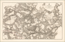
Rare Plan of the Siege of Yorktown Drawn From A Contemporary British Manuscript Plan
Finely constructed military battle plan, illustrating the British defense and joint American and French Siege of Yorktown and Gloucester, engraved for William Faden from an original manuscript survey by Lieutenant John HIlls, a draughtsman, surveyor and mapmaker who served in the British Army from 1778 to 1783.
Like its manuscript predecessor drawn by Hills, the plan is focused on the defensive positions fortified by the British around Yorktown and Gloucester, with the positions of the American and French forces arrayed around the south perimeter of Yorktown. The Hills plan is a remarkable counterpoint to the Esnauts & Rapilly naval plan of the siege and blockade, which gives the wider view of the theater of war, which would end with Cornwallis's surrender on October 17, 1781 to Washington and Rochambeau.
The positions of British commands and artiillery are meticulously shown, with the lines of fire, shown here in red, drawn with careful precision, reflecting not just the lines themselves but also the different strengths of each battery. Further out of town, the British infantry positions are shown behind fortified lines and redoubts, again identifying officers and/or regimental numbers. At the outermost line of the British positions, at least one position already lost by the British is shown.
Offshore, two British ships, the Guadaloupe and Charon are shown. The Charon was the largest of 70 British warships trapped by the unseen naval siege. Her guns would be stripped for use ashore and the Charon ultimately burned to the waterline under French cannon fire. The British ship Guadaloupe came under fire from shore batteries, with the decision made to scuttle the ship in the York River on October 10, 1781, to prevent the French capturing her.
In front of Yorktown, over 3 dozen ship masts protrude from the water, identified as Sunken Vessels, a muted reflection of the waters in front of Yorktown at the culimination of the siege.
The Hills plan is one of the three great plans of Yorktown, with one produced by each of the major combatants, the Hills published by the British, the Bauman by the Americans and the Esnauts & Rapilly by the French. Each of the three uniquely captures the national perspective of its publisher. The Esnauts provides an unparalleled image of the naval blockade of the Cheaspeake. The Bauman illustrates the stong position of the allied American and French forces with meticulous detail, with only a small hint of the French naval contingent and relatively modest depiction of the British positions and artillery reach. The Hills focuses closely on the British positions, strong and well constructed, with remarkable artillery coverage. Only a prolonged seige by a determined adversary, reinforced by another of the world's superpowers, could ultimately result in capitulation.
The Hills plan, perhaps better either of the other major plans, captures in detail the true situation of the British under Cornwallis at the height of the siege. While the Bauman plan is of great import, the Bauman's scale is significantly smaller and offers far less detail regarding the British battle positions (which are likely quite inaccurate), with no real sense of the Frenh-led blockade. The Bauman's merit lies with its treatment of the positions of the American and French forces. The Esnauts & Rapilly pays the highest tribute to the French naval blockade, minimizing the scale and detail of the forces of the competing armies. The Hills plan conveys pride of position and organization, even in defeat.
Each of the three maps is quite rare on the market. Recent market history suggests that the Faden is likely the rarest of the three.
John Hills
John Hills was active in America as a draughtsman by 1778, creating a number of noteworthy manuscript maps for the British Army. Hill was commissioned on July 6, 1778 as an ensign in the 38th Regiment of Foot. Hills was one of one of three “extra draughtsman” assigned to the command of John Montresor, the Chief Engineer of the British Army, a position held only briefly in 1778. After an unsuccessful stint under the command of George Rochfort, Hills worked as an assistant engineer in early 1780 under Alexander Mercer, Chief Engineer in New York, where he continued his work as a mapmaker and made at least one trip to the front lines, where he was wounded by American musket fire near Springfield, New Jersey, in June 1780.
Hills remained in America until well after Cornwallis's surrender at Yorktown, creating over 30 surviving manuscript maps of battles, marches and other works of great historical interest during his time serving in the British Army, from which he resigned on April 7, 1784. He may have remained in America, as he would go on to create a number of maps advertised in New York newspapers as early as 1784. Hills maps would be the subject of letters written by George Washington, Henry Knox, Alexander Hamilton, John Jay, and others. His plan of Philadelphia is especially noteworthy.
Rarity
The Hills / Faden Plan of Yorktown is very rare on the market, likely due in large part to its being the culmination of Britain's failed efforts to defend its American Colonies.
We note a single example of the separate battle plan listed in dealer catalog listed in AMPR (1988) and only two auction records in RBH since the Streeter sale in 1967.
![(American Revolution - Virginia Privateering) Manuscript Document Concerning the American Privateer Grand Turk, Captured Near Scotland's Fair Isle by Michael Griff [The Capt. of the Privateer Michael Griff declares as follows ...]](https://storage.googleapis.com/raremaps/img/small/82328.jpg)

![[ Carolinas & Georgia ] Virginiae Partis australis, et Floridae partis orientalis, interjacentiumqus regionum Nova Descriptio](https://storage.googleapis.com/raremaps/img/small/81554.jpg)
![A New and Exact Map of the Dominions of the King of Great Britain on ye Continent of North America . . . [Beaver map]](https://storage.googleapis.com/raremaps/img/small/101277.jpg)