|
||

|

|
|

|
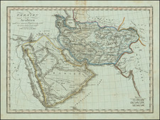
Rare map of the Arabian peninsula John Seller in 1679, which appeared in his Atlas Minimus.
John Seller, a pioneering English cartographer of the seventeenth century, was renowned for his detailed and meticulously crafted maps that greatly contributed to the English speaker readers' geographical knowledge of his time. Among his widely recognized works is the Atlas Minimus, a fascinating and diminutive atlas featuring a myriad of geographical locations worldwide. Of particular interest in this mini compendium of maps is Seller's depiction of Arabia, which Seller divided into three distinct sections: Arabia Petraea (the Stony), Arabia Deserta (the Desert), and Arabia Felix (the Happy).
To fully appreciate Seller's map, one needs to understand the historical context and the sources of information at his disposal during the time of its creation. The three-part division of Arabia was not a novelty introduced by Seller; it was a prevalent classification that dated back to ancient Roman and Greek geographers, such as Ptolemy. This division provided a simplified representation of the Arabian Peninsula's vast diversity and complexity. As such, Seller's map is a testament to the endurance of these traditional classifications into the era of modern cartography.
Arabia Petraea, or 'Stony Arabia,' as represented in Seller's map, corresponds to the northwestern part of the Arabian Peninsula, encompassing parts of modern-day Jordan, northwestern Saudi Arabia, and southern Israel and Palestine. This region was known for its rocky terrain and was the location of the famous Nabatean city of "Herat formerly Petra." Seller's portrayal, although not extraordinarily detailed given the scale of the Atlas Minimus, reflects the region's topography and its stark contrast to the other two parts of Arabia.
Arabia Deserta, 'the Desert Arabia,' corresponds to the vast desert interior of the Arabian Peninsula, which includes much of modern-day Saudi Arabia. This region is characterized by its arid climate, sparse vegetation, and the iconic sand dunes often associated with the Arabian landscape. Seller's depiction of this region in the Atlas Minimus is indicative of the prevailing European view of Arabia as an inhospitable desert, a notion that was, to some extent, grounded in reality but also perpetuated by the limited interaction between Europe and the interior of Arabia.
Lastly, Arabia Felix, or 'Happy Arabia,' corresponds to the southern part of the Arabian Peninsula, including modern-day Yemen and parts of Oman. The term 'Felix,' meaning fortunate or happy, was used to describe the region's relative fertility and wealth compared to the rest of Arabia. This area was known for its spice trade, which was a significant source of wealth and a key factor in the region's interaction with the Roman Empire and later with Europe. In Seller's map, this region appears distinct from the other two parts of Arabia, underscoring the region's historical reputation as a land of prosperity amidst an otherwise harsh and challenging environment.
Rarity
The map is very rare on the market. This is the first example we have offered for sale.
John Seller was one of the most notable map and instrument makers in England in the late-seventeenth century. He was especially known for the sea charts, many of which featured in his influential English Pilot and Atlas Maritimus. Seller was born in London in 1632. His father was a cordwainer and John was apprenticed to Edward Lowe, of the Merchant Taylors’ Company. He was made free of that company in 1654. Later, he also was made a brother of the Clockmakers’ Company, which housed several instrument makers. He started business as a compass maker but expanded his offering to include navigational instruments and charts.
Seller’s career was halted temporarily, and fantastically, when he was tried for high treason in 1662. He was accused of involvement in a plot led by Thomas Tonge. While Seller likely only unwisely repeated rumors, he was convicted. The other conspirators, who did admit some degree of guilt, were executed, but Seller maintained his innocence and, via insistent petitions, he eventually secured his release from Newgate Prison.
This episode did not seem to slow Seller’s rise too much, however. Seller was granted a royal license to publish English-language maritime atlases. This gave him a near-monopoly and led to his being named hydrographer to the King in 1671. Although the point of the project was to produce English charts of Dutch dominance and bias, Seller ended up using many Dutch plates as his base material. The first volume of The English Pilot was published in 1671, followed by more volumes as well as The Coating Pilot (1672) and the Atlas Maritimus (1675). Seller was commercially successful, but some of his projects required further support. The English Pilot was eventually taken over by John Thornton and William Fisher, for example, and his proposed English atlas only produced maps of six counties.
Seller’s sons, John and Jeremiah, followed in their father’s profession. Seller also apprenticed several promising young men, including Charles Price, with whom his sons partnered. Through Price, Seller can be seen as the founding figure of an important group of London mapmakers that included Price, John Senex, Emanuel Bowen, Thomas Kitchin, and Thomas Jefferys.
![[Ottoman-Turkish Map of the Middle East]](https://storage.googleapis.com/raremaps/img/small/81188.jpg)
![[Arabian Peninsula] Sexta Asie Tabula [Arabia Felix.]](https://storage.googleapis.com/raremaps/img/small/84313.jpg)