|
||

|

|
|

|
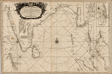
Rare London published map of centered on Thailand and the Malaysian Peninsula by John Seller, which appeared in his highly regarded Atlas Minimus in 1679.
The map identifies VII Kingdoms, where were:
-
Aracan: This refers to the historical region of Arakan, also known as Rakhine State, located on the western coast of Burma (Myanmar). It's famous for its independent kingdoms and unique cultural traditions that existed for centuries before falling under Burmese control in the late 18th century.
-
Pegu: This represents the old kingdom of Pegu, or Bago, which was a major power in present-day Myanmar. The kingdom was known for its architectural and cultural achievements, including the construction of numerous pagodas.
-
Siam: This kingdom corresponds to the historical region that is now modern Thailand. Siam was a powerful and independent entity during the era, known for its strong governance system and cultural influences that continue to persist in Thai society today.
-
Malacca: This kingdom corresponds to the historic sultanate of Malacca on the Malay Peninsula. It was a major trading port and had significant influence on the maritime trade routes between China and India in the 15th and 16th centuries.
-
Tunquin: This refers to Tonkin, the northernmost part of Vietnam, which was historically a separate political entity. Its culture and traditions have significantly contributed to the overall Vietnamese identity.
-
Cochinchina: This corresponds to the southern region of Vietnam, known for its fertile plains and historic conflicts. It became a French colony in the mid-19th century.
-
Cambodia: This kingdom refers to the historic region that is now the modern state of Cambodia. This area was home to the powerful Khmer Empire, known for constructing the famous Angkor Wat temple complex.
The map's depiction of these seven kingdoms offers an intriguing view of Southeast Asia from the perspective of a 17th-century European cartographer. Although the map reflects a European viewpoint and carries the limitations of the era's geographic knowledge, it remains a valuable document for understanding historical geography and the European perception of Asia during the time.
Rarity
This is the first time we have offered the map for sale.
John Seller was one of the most notable map and instrument makers in England in the late-seventeenth century. He was especially known for the sea charts, many of which featured in his influential English Pilot and Atlas Maritimus. Seller was born in London in 1632. His father was a cordwainer and John was apprenticed to Edward Lowe, of the Merchant Taylors’ Company. He was made free of that company in 1654. Later, he also was made a brother of the Clockmakers’ Company, which housed several instrument makers. He started business as a compass maker but expanded his offering to include navigational instruments and charts.
Seller’s career was halted temporarily, and fantastically, when he was tried for high treason in 1662. He was accused of involvement in a plot led by Thomas Tonge. While Seller likely only unwisely repeated rumors, he was convicted. The other conspirators, who did admit some degree of guilt, were executed, but Seller maintained his innocence and, via insistent petitions, he eventually secured his release from Newgate Prison.
This episode did not seem to slow Seller’s rise too much, however. Seller was granted a royal license to publish English-language maritime atlases. This gave him a near-monopoly and led to his being named hydrographer to the King in 1671. Although the point of the project was to produce English charts of Dutch dominance and bias, Seller ended up using many Dutch plates as his base material. The first volume of The English Pilot was published in 1671, followed by more volumes as well as The Coating Pilot (1672) and the Atlas Maritimus (1675). Seller was commercially successful, but some of his projects required further support. The English Pilot was eventually taken over by John Thornton and William Fisher, for example, and his proposed English atlas only produced maps of six counties.
Seller’s sons, John and Jeremiah, followed in their father’s profession. Seller also apprenticed several promising young men, including Charles Price, with whom his sons partnered. Through Price, Seller can be seen as the founding figure of an important group of London mapmakers that included Price, John Senex, Emanuel Bowen, Thomas Kitchin, and Thomas Jefferys.
![(Rare copperplate edition!) Asia Secunda Pars Terrae in Forma Pegasi [Asia in the Form of Pegasus]](https://storage.googleapis.com/raremaps/img/small/82046.jpg)
![[ Southeast Asia ] Tabula Nova Indiae orientalis & meridionalis](https://storage.googleapis.com/raremaps/img/small/100399.jpg)