|
||

|

|
|

|
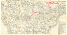
"The Largest Specimen of Geographical Design Ever Produced In the United States" (The Port Folio, 1815)
Fine example of Samuel Lewis' monumental map of the United States, the largest and possibly the most expensive map published in America to date.
Lewis's work is a singular composition of detail and scale, illustrating the American Republic following the close of the War of 1812, at a moment when American expansion was about to explode. Large parts of Alabama and Georgia had recently been opened to settlement. Indiana and Illinois were on the verge of statehood. The accounts of Zebulon Pike and Lewis & Clark were inspiring a significant push westward, intensified by the belief in manifest destiny, federally issued Indian removal acts, and economic promise. A new era of settlement and opportunity opened beyond the Ohio and Mississippi River Valleys, and no map better illustrated this remarkable expanse of land than Samuel Lewis's 1816 map.
Samuel Lewis was among the most important early American mapmakers, collaborating with Matthew Carey, John Reid and a number of his contemporaries in the compilation and production of early maps of the American states, etc. This is Samuel Lewis's first wall map of the United States, a project which he undertook with Emmor Kimber (1775-1850). Kimber a Philadelphia based bookseller, publisher and Quaker Minister, would also publish editions of Reading Howell's map of Pennsylvania in 1816 and 1817.
Ristow notes the southeast (title) sheet, dated 1815, was likely deposited in the copyright office in 1815, but found no evidence that the map was completed until 1816, with a revised 1816 date in the title (Ristow, p 266). Rumsey notes that the 1816 map is the first complete edition of this map, as well as the largest wall map of the United States produced by Americans at that time.
At a final price of $22.00, the map was not only the largest ever map published in the United States, it was likely the most expensive. On March 22, 1816, Emmor Kimber wrote to Thomas Jefferson
Esteemed friend Thomas Jefferson
At a very great expense, and by the industry and labour of several years, I have at length produced a large and elegant Map of the United States—The draftsman employed to effect this was Samuel Lewis, and the engravers William and Samuel Harrison—A few copies of the first attempts at finishing them, have been deposited in the publick offices at Washington, and which I hope thou hast seen—
I am now prepared to publish the Map, and my agent Solomon Humphreys, who is to supply subscribers with it, will leave this City in about two weeks, on a journey through the Southern States, who will have in charge a copy to offer for thy acceptance—What reception he may meet with from the publick, or to what extent I shall be remunerated for my labour, is to be proved—but I have beleived, if thou approves of the attempt to produce from the best information practicable, such an extensive Map, and was free to communicate thy approbation to me, by a letter that thou would be willing I should print annexed to the enclosed review, it would be of extensive benefit to me, and of great advantage to my agent in disposing of them
from thy friend Emmor Kimber
The Papers of Thomas Jefferson describe the enclosed review as follows:
the enclosed review praised the accuracy and execution of the map; noted its utility both for “foreigners” and “natives of the soil”; asserted that “there are among us but few individuals, not excepting those of the most respectable acquirements, who are not better acquainted with the geography of Europe, and even of some parts of Africa, than they are with that of the United States”; claimed that “Were a map of this description hung up in the hall of every family of our country, able to afford it, the children of the people of the United States would become geographers by instinct”; observed that “Kimber’s map being, in the true sense of the word, a national work, creditable to the country, and finished after six years of labour and trouble, and at an expense that must have been seriously felt by the resources of an individual, it is hoped that it will be received under national patronage”; and concluded that, although not “free from errors and defects,” those faults “are so few and inconsiderable that a detailed notice of them might justly be deemed hypercritical and superfluous” . . . .
It does appear that Lewis made a serious effort to market the map in the south, with newspaper advertisements appearing in the Richmond Enquirer (November 16,1816) The Carolina Federal Republican (June 14, 1817), as well as in other parts of America and Europe.
The Map
First and foremost, the map is noteworthy for its scale. The Lewis map was the largest map of the United States ever printed. The size of the map dwarfs even the largest of its contemporaries, nearly 2.5 times larger than the Melish and Bradley Postal maps and 40% larger than Amos Lay's maps of the 1820s. It would remain unrivaled until J Calvin Smith's map of the United States and Canada, first published in 1843, which is of a nearly identical size and coverage area.
The second feature which immediately appears on the map is its extraordinary attention to topographical details. The map far surpasses the contemporary maps by Bradley, Arrowsmith, Shelton & Kensett in its depictions of the mountain ranges east of the Mississippi River, and provides a level of artistry not present any earlier or contemporary map of the United States.
The map extends farther into the Northwest Territory and the the northern part of Missouri Territory than any prior map, reaching the Kansas Villages, Eastern Texas and well into the Plains. Unlike the Bradley map, the Lewis map covers all of Lake Superior and the sources of the Mississippi River, pushing beyond Leech Lake to Upper Red Cedar Lake, which would become the known source of the Mississippi River for the next several decades.
The map shows 3 roads extending to St. Joseph Michigan (not on the Bradley or other early maps), coming from
- Detroit, via 2 Poutewattimis villages
- Fort Defiance, Indiana
- Fort Ouiatenon (modern West Lafayette) Indiana
In Georgia the Indian Boundary Line is shown, along with a number of early roads in Southern Georgia not present in Bradley's Postal Map
David Rumsey notes that much of the map's road information was drawn from from the 1812 state of Abraham Bradley postal map of the United States. He notes that the map is similar to the Arrowsmith 1819 in the northwestern areas, but closer to the Tardieu 1818 in the Michigan Peninsula area, suggesting that Arrowsmith and Tardieu drew there information from the first state of Lewis's map or an unknown common source.
States of the Map
The map is known in at least two states and possibly three, identifiable by the changing dates:
- 1816: Illinois and Indiana are territories. Mississippi Territory includes Alabama. No Arkansas Territory
- 1818: lllinois and Indiana are now states. Florida inset added. Alabama Territory is created from the eastern part of Mississippi. Arkansas Territory added.
- 1819: Rumsey suggests the existence of 3 states, the third dated 1819. The note below is derived from Rumsey's catalog.
This 1818 edition has a printed notation on the U.S. Mexican boundary: "Boundary between the U. States and the Spanish Provinces agreeable to the Treaty of 1819." This indicates that the map was published late in 1818 or early in 1819, either in anticipation of the February, 1819 signing of the treaty, or just after it.
Rarity
The map is of the utmost rarity. We are aware of only a single example (this copy) on the market in the past 30 years.
We note examples in the following collections:
- 1816: Library of Congress, Stanford/Rumsey Center (acquired 1996), University of Southern Maine/Osher Library, Amerian Antiquarian Society, MacLean Collection
- 1818: Stanford/Rumsey Center (acquired 1994); Bibliotheque National de France; Wurtemberg Library (Germany); Private American Collection, MacLean Collection
- 1819: None listed in OCLC, but referenced by Rumsey and Ristow.
Provenance: Old Print Shop.
The Papers of Thomas Jefferson, Retirement Series, Volume 9; 1 September 1815 to 30 April 1816.
The Port Folio, 3rd Series, Vol. 6 (1815) p. 304.
![[ British Colonies in North America ] Carte Nouvelle de L'Amerique Angloise contenant tout ce que les Anglois possedent sur le Continent de L'Amerique Septentrionale . . .](https://storage.googleapis.com/raremaps/img/small/100143.jpg)
![(Lasalle's Final Expedition) Dernieres Decouvertes dans L'Amerique Septentrionale de M. De La Sale [i.e., La Salle], Mises au jour par M. le Chevalier Tonti, Gouverneur du Fort Saint Louis, aux Islinois.](https://storage.googleapis.com/raremaps/img/small/69476.jpg)