


|
||

|

|
|

|
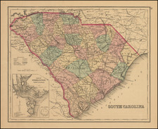
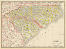
Gorgeous large format railroad map of North Carolina and South Carolina, hand colored by counties.
Shows railroads, towns, rivers, lakes, mountains, township surveys, etc.
Includes numerous railroad lines and stations.
Asher & Adams was a New York publishing firm known for their atlases. Notably, their maps were some of the first to prominently exhibit railroad lines, even if this meant a slight reduction in topographical detail. They specialized especially in state and county maps of the United States.
Asher & Adams was a New York publishing firm known for their atlases. Notably, their maps were some of the first to prominently exhibit railroad lines, even if this meant a slight reduction in topographical detail. They specialized especially in state and county maps of the United States.
![(Southeast United States) Carte de la partie sud, des Etats Unis de L' amerique septentrionale [Map of the southern part of the United States of North America]](https://storage.googleapis.com/raremaps/img/small/98738.jpg)