


|
||

|

|
|

|
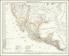
Detailed Map of Native American Incursion Routes from Texas into Mexico
This untitled map shows a portion of the Texas - Mexico border, roughly the area from the Big Bend to the town of Mier, outlining in red the principal routes used by Native Americans on their incursions from Texas into the northern state of Nuevo Leon, Mexico. The map also notes the meeting points ("puntos de reunion") for the Native Americans during their Mexican incursions. The map is based on earlier work by F. L. Mier and has the following interesting note printed in the lower margin, which relates to its use in stationing military detachments in order to interrupt the Native American attacks originating from Texas:
Nota. - Indica este Mapa los principales puntos de pasaje de los indios en el Rio Grande, para venir desde los Estados Unidos á hostilazar á México. Señala con exactitu[de] las montañas, los valles que forman, y sus gargantas, para demostrar la conveniencia de la ocupacion de determinados puntos por destacamentos militares, que dificultarian la[s] incursiones.
The map shows the Mexican states of Nuevo Leon and Coahuila, with parts of Chihuahua, Durango and Tamaulipas, showing rivers, mountainous areas, cities, towns, routes of Indians, and roads.
Based on maps by S. Mc. L. Staples (1828); Nigra de San Martin; and García Cubas, per printed note:
Copiado del Mapa de S. Mc. L. Staples, en 1828; del Mapa de Nigra de San Martin en cuanto á las distancias respectivas, y de la Carta general de la República Mexicana de García Cubas; y segun los informes fidediguos de personas que conocen el terreno, especialmente la parte mas al Norte á la derecha del Rio Bravo.
Translation of note:
Copy of the Map of S. Mc.L. Staples in 1828; of the map of Nigra de San Martin which shows the respective distances and of the general drawing of the Mexican Republic by Garcia Cubas and according to the information of persons who know the land, especially to the part north of the Rio Bravo (Rio Grande).
The Mexican commission that issued this map was charged with investigating the recurring Native American depredations into Mexico, cattle rustling, and general chaos along the Texas-Mexico borderlands. The map appeared with a report on problems along the Texas border which focused on Indian depredations into Mexico. The title of the report was: Informe de la Comisión Pesquisidora de la Frontera del Norte ... Sobre Depredaciones de los Indios y Otros Males que Sufre la Frontera Mexicana (Mexico, 1874).
Rarity
A very rare map of the Texas-Mexico border region, with detailed information on Native American tribes.
![[Matagorda Bay] Bahia De S. Bernardo](https://storage.googleapis.com/raremaps/img/small/54374.jpg)
![Map of Texas [with] inset of N.W. Part of Texas](https://storage.googleapis.com/raremaps/img/small/84519.jpg)