|
||

|

|
|

|
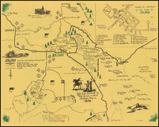
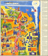
Early Automobile Touring Pictorial Map of the Oregon Cascades
Interesting pictorial map and brouchure, promoting the Oregon Cascades and the McKenzie River Highway Company, published by the Bend Chamber of Commerce in cooperation owth the commercial organizations of Redmond and Eugene Oregon.
The map extends from Portland the Columbia River in the north to Klamath Falls, Ashland and Grant's Bend in the south, focusing the new automobile tourist routes through the region. Centered on the road between Eugene and Bend Oregon along the McKenzie River and through Mount Washington and the Sisters, this early promotional map emphasizes the rugged terrain, mountains, rivers and towns immediately East of the Cascade Mountains.
Among the other roads noted ar the Dalles-California, Wapinitia, Mt. Hood Loop, McKenzie and Ochoco Highways.
McKenzie River Highway
The McKenzie River Highway in Oregon has a rich history dating back to the early 19th century. European explorers began exploring the southern Willamette Valley in 1812, hunting and trapping fur animals. One of these explorers was Donald Mackenzie, who spent six weeks in the area. His name was first put on a map of the river in 1824 by the Hudson's Bay Company, making the McKenzie River one of the few in Oregon not to keep its original Native American name.
A significant milestone occurred in 1853 when scouts from "The Lost Wagon Train" traveled the whole length of the river for the first time. They found their way down the McKenzie River from the east side of the Cascades, opening up the river's potential as a route. The area then began to attract homesteaders, with the first claim recorded in 1861 by James Belknap near the South Fork McKenzie.
In the 1870s, the area started becoming a tourist spot. Two hot springs resorts opened in the upper McKenzie River area, attracting visitors to the region. The wagon road also had stops every 6 to 10 miles, leading to the formation of the communities that we see along the river today.
By 1893, all the land in the McKenzie River watershed not already owned by homesteaders became part of the National Forest or Bureau of Land Management. This designation preserved the area's natural beauty and resources for future generations.
The McKenzie River Highway began to see automobile traffic in the early 1900s. The beautiful scenery along the river made it a popular destination for motorists, leading to its growing reputation as a picturesque route. Fishing lodges also sprang up along the highway, offering further attractions for visitors.
Fred Routledge (1871-1936) was an Oregon artist and pictorial mapmaker, who spent much of his professional life as a correspondent for the Morning Oregonian. His career lasted from the 1890s to the early 1930s. Routledge was a well regarded artist, who received awards for his paintings, including a first prize at the 1915 Panama-Pacific Exposition in San Francisco. His ephemeral work as a pictorial cartographer was also very well regarded.
Routledge was born in Abilene, Kansas, raised in Rockford, Illinois, and settled in the Portland area in 1886 with his family. He began working as an illustrator with the West Shore publication before its demise in 1891, thereafter finding wor at the Oregonian in 1895. The January 1, 1896 "Where Rolls the Oregon," is his first work of significant note.