


|
||

|

|
|

|
Stock# 91601
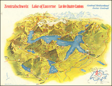
Description
Rare promotional pamphlet and ski touring map of Parsenn, Davos and Klosters region of Austria, by H. Hoek, printed and published by Conzett & Huber and cartographers, “Aerovue” publishing house, Zurich.
In addition to the map and guide, there are 32 ski photos of the area, and we join with the offering 3 contemporary post cards.
The map feature symbols and annotations applicable to an Alpine Mountain ski map, integral for understanding the terrain, paths, and facilities available to skiers and hikers in mountainous regions. These include:
- Ski routes ("Skirouten"): Marked paths intended for skiing, usually away from groomed ski pistes.
- Difficult and avalanche-dangerous spots ("Schwierige und Lawinengefährliche Stellen"): Areas that are difficult to navigate due to terrain and have a high risk of avalanches.
- Nursery slopes ("Übungsfelder"): Designated areas suitable for beginners or those in ski school learning to ski.
- Excursions en ski ("Ski-Tours"): Routes designated for longer ski tours, possibly off-piste.
- Danger of avalanches ("Passages difficils et danger d’avalanches"): Specific routes or areas where there is a known risk of avalanches.
- Alpine rescue stations ("Alpine Rettungsstationen"): Locations where mountain rescue teams are stationed or where emergency equipment is stored.
- Snow shovels and sounding rods ("Lawinenschaufeln und Sondierstangen"): Indicates areas where these avalanche rescue tools can be found or suggests carrying them.
- Emergency sledges ("Rettungsschlitten"): Locations where emergency sledges for evacuation in case of injury are available.
- Main and secondary roads ("Haupt- und Nebenstraßen"): The primary and less major roads accessible in the area.
- Drives, bridle paths, and footpaths ("Fahr-, Saum- und Fußwege"): Different types of paths suitable for vehicles, horses, and pedestrians, respectively.
- Principal railroad ("Hauptbahn"): Main railway lines running through or near the area.
- Cable railway ("Seilbahn"): Indicates the presence of a cable car or aerial lift system.
- Funicular railway ("Funiculaire"): A type of cable-driven railway system, typically used on steep slopes.
- New height points ("Höhenpunkte (neue Höhe)"): Points of elevation newly marked or important for orientation.
- Churches, chapels ("Kirchen, Kapellen"): Indicates the locations of religious buildings, which can also be landmarks for orientation.
- Contour intervals and curves ("Equidistance: Courbes de niveau"): Represent the vertical distance between contour lines on the map, indicating the steepness of slopes.
These symbols are standard for Alpine maps, aiding in navigation and safety for all engaging in activities in these areas.
Condition Description
Folding map in folio with booklet and three postcards.
![(Basel, Switzerland and southern Germany) Basiliensis Territorii Descriptio Nova [with] Circulus Sive Liga Suevia Vulgo Schwabische Kraiss](https://storage.googleapis.com/raremaps/img/small/82573.jpg)
![[ Rare Imprint -- Theater of War in Europe ] Le Royaume de France divise en Toutes ses Provinces / Groot Toneel des Oorlogs, tusschen de Geallierrede Moghendhen en het Fransche Ryk -- Grand Theatre de la Guerre entre les Puissances Alliees et L'Empire Francois . . .](https://storage.googleapis.com/raremaps/img/small/104046.jpg)