|
||

|

|
|

|
The 101 is Born.
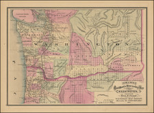
This 1928 map, entitled Pacific Coast Highways Canada to Mexico, produced by The Texas Co., stands as a remarkable early depiction of the 101 highway, detailing its path from Vancouver to San Diego through a series of 11 strip maps, along with two eastward-looking color bird's-eye views of the northern and southern sections of the U.S. Pacific coast.
The 1920s was a time of rapid growth and development in the United States, particularly in the transportation sector. The construction of the U.S. Route 101 marked a significant step towards connecting communities along the West Coast, and this map serves as a testament to the engineering and societal aspirations of the time. The cover title, Tour Maps Routes and Mileages Canada to Mexico - Washington, Oregon California and parts of Nevada and Idaho, indicates the map's original utility as a traveler's guide and a symbol of mobility and progress.
The main image of the map, comprised of 11 strip sections and color bird's-eye views, emphasizes not only the geographical layout of the highway but also captures the breathtaking landscapes and diverse topography of the regions it traverses. The careful rendering of the northern and southern sections provides a rich visual experience that resonates with the spirit of adventure and exploration that characterized the era. Moreover, the highlighting of the 101 offers a glimpse into the cultural significance of this iconic route as a symbol of connection and unity across vast distances.
On the verso, the more standard map of the western U.S. and the comprehensive index of cities and towns reflect the practical application of the map. It becomes more than a mere representation of geographical data, serving as an artifact of the time that exemplifies the combination of utility, artistry, and innovation. The detailed index and thoughtful design transform the map into an enduring historical document that captures the essence of a pivotal period in American transportation history.