|
||

|

|
|

|
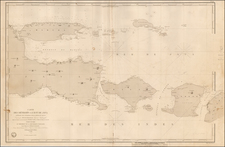
Map of The Territory of New Guinea, administered by The Commonwealth of Australia under mandate from The League of Nations, and Papua A Territory of the Commonwealth of Australia, was published by H.E.C. Robinson Pty Ltd. in Canberra, Australia, in 1930. This map provides a detailed representation of Papua, New Guinea, and the surrounding islands, showcasing the geopolitical boundaries and administrative divisions of the period.
The Interwar years, following the conclusion of the First World War, brought about significant territorial adjustments. The League of Nations, aiming to ensure stability and peace, entrusted the Commonwealth of Australia with the administration of New Guinea, previously under German control. This transition is evident in the map's delineation, which carefully marks the "Boundary of Australian Mandate." Concurrently, Papua's representation on the map, under Australian jurisdiction since 1902, highlights the nuanced governance model of the region during this period.
The detailed depictions on this map provide geographical insights and serve as a testament to the political and administrative changes occurring in the Pacific region in the early 20th century.
![(First state!) [ Southeast Asia ] Tabula Asiae XI](https://storage.googleapis.com/raremaps/img/small/94616.jpg)