|
||

|

|
|

|
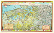
This Map of the Surveyed Portion of Chehalis County, Washington, compiled and drawn from U.S. Surveys and published by C.H. Fenner in 1890, is a significant map for this portion of the Pacific coast of Washington. As the County Surveyor, Fenner used official surveys to depict the county's geography and development.
The map distinguishes boundaries, wagon roads, and railroads. It differentiates between operational railroads and those still under construction or proposed, providing an insight into the county's transportation infrastructure at the time.
The inclusion of soundings, or water depth measurements, indicates navigable routes and helps in understanding the maritime activities prevalent during that period.
Important locations such as Gray's Harbor, South Harbor, Ocosta, and the Town of Peterson are clearly marked. Gray's Harbor, a crucial seaport, is a significant feature on the map.
The map was originally copyrighted by C.H. Fenner in 1886. Its original covers, dated 1891, suggest its use as a public resource. Overall, it provides a snapshot of Chehalis County's development at the end of the 19th century.
![[San Francisco to British Columbia] Carta particolare dello stretto di Iezo fra l'America e I'Isola Iezo . . . D'America Carta XXXIII](https://storage.googleapis.com/raremaps/img/small/67788.jpg)
![[ North Fork Snoqualmie River -- Calligan Lake ] Township No. 25 North, Range No. 9 East.](https://storage.googleapis.com/raremaps/img/small/101663.jpg)