|
||

|

|
|

|
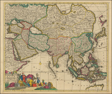
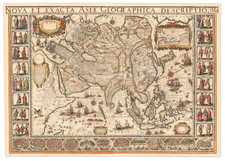
Fine Decorative Map of Asia
Detailed and attractive, separately-issued map of Asia by Tavernier, based on the work of Petrus Bertius.
The map encompasses the entirety of the continent, including the Arabian Peninsula, the Indian subcontinent, Maritime Southeast Asia, and Japan. A sliver of the American continent, separated from Asia by an unnamed strait, is in the upper right corner. In the lower left, a considerable portion of East Africa is featured, with an emphasis on the Nile.
Place names are spread throughout the map, but they are especially thick in the Arabian Peninsula, Persia, and Southern India. There are fewer toponyms and less definite borders in parts of Maritime Southeast Asia, Nova Zembla, and Northeast Asia. These areas were still being encountered and charted by Europeans, hence their lack of assurance here. Korea is shown as a peninsula, which is different than on a comparable contemporary map by Blaeu. Japan is shown in a horizontal position, a typical depiction for the early seventeenth century.
Although focused on the geography of the continent, the map also has a few embellishments. In Africa, there is a pair of lions in Egypt. An elephant is in upper India, near Lake Chiamay. Both a note and a depiction of the Great Wall of China separate China from Tartary. At sea, several ships—European and Chinese—are sailing. They would do well to look out for sea monsters, which are also in the waters. A cherubic mermaid is also in the water, blowing a horn.
The publisher’s cartouche is in the upper left corner, tucked into mainland Europe. In the upper right corner, another cartouche carries the title and acknowledgment of the work of Bertius.
Melchior Tavernier was a member of a large family involved in the publishing trade in Paris in the early years of the seventeenth century. Early in his career, he apparently collaborated with Henricus Hondius, as at least one of his early maps references Tavernier as the seller of a map engraved in Amsterdam, by Hondius. He is probably best known for his publication of a map of the Post Roads of France, which was copied many times until the end of the century. He also issued an atlas under the same title as J. le Clerc's Theatre Geographique, using many of Le Clerc's maps, but incorporating others from different sources. He published composite atlases and also published works for other cartographers, including N. Sanson, N. Tassin, and P. Bertius. He is not to be confused with his nephew of the same name (1594-1665), who also engraved maps for Nicolas Sanson.
![[Spectacular Set of Wall Maps of the Continents Dedicated to King Charles II of England, &c.]](https://storage.googleapis.com/raremaps/img/small/93614.jpg)