|
||

|

|
|

|
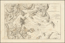
A Map of Monumental Importance -- Illustrating The French Blockade of the Chesapeake and Battle of Yorktown, The Decisive Battle of the American Revolution.
Exquisitely-hand-colored example of Esnauts and Rapilly's depiction of the Battle of Yorktown, one of the definitive cartographic representations of the naval engagements connected with the Siege of Yorktown, the decisive battle of the American Revolution.
The present map is an entirely original work compiled from French sources, for which no American or English edition exists. Along with Sebastian Bauman's map, it is one of only two contemporary large-format maps of Yorktown and the only map to focus on the French naval blockade. The Bauman, printed in Philadelphia in 1782, primarily shows the area immediately around Yorktown and the York River and does not display the important naval action.
Pritchard and Taliferro (Degrees of Latitude) note that the present map:
depicts a dramatic, somewhat stylized version of the important role the French navy played in the American victory at Yorktown. Designed for the French market, the map illustrates … the French position at the mouth of the Chesapeake Bay. Admiral Graves' fleet is pictured as they prepared to sail for New York.
The Battle of Yorktown
By May 1781, Virginia had become the main theater of war in America. The small allied force under the Marquis de Lafayette was no match for the combined British armies commanded by Lord Conwallis and Benedict Arnold. Much of eastern Virginia, particularly the country along the James was ravaged. In June, Cornwallis moved towards Williamsburg and Yorktown with instructions to establish a post at the mouth of Chesapeake Bay. He was closely shadowed by Lafayette at a distance of about twenty miles to the north.
In August, General Washington, then positioned on the Hudson River, received word that the French Admiral Comte de Grasse had left the West Indies with a fleet of twenty-eight ships of the line, six frigates, and three thousand troops bound for the Chesapeake Bay. Washington and the French Commander, Rochambeau, abandoned their plan to attack New York and marched their troops to Virginia. De Grasse arrived at the Chesapeake on August 26th, disembarked his troops and blockaded the entrance to the bay.
The British Navy, led by Admiral Graves, arrived in Virginia in early September. In the subsequent battle, the British fleet was heavily damaged and withdrew to New York. By September 26th, the American army had arrived and blockaded the British Army at Yorktown. The scene was set for a complete encirclement of the British forces. Despite numerous breakout attempts, none succeeded, and after heavy shelling, the British troops were forced to surrender.
Rarity
Esnauts and Rapilly's map is widely regarded as one of the most important and sought-after of all battle plans of the American Revolution and one of the very few to be drawn from a French eyewitness perspective. The map is quite rare on the market, with only a few examples changing hands in the past twenty-plus years.
![[ Florida Native Americans -- Idol Worship ] Idolum Kiwasa XXI](https://storage.googleapis.com/raremaps/img/small/98017.jpg)