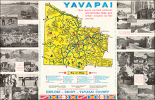
|
||

|

|
|

|
The Map that Ended the Myth of California as an Island
Kino’s important map of California, showing it as part of North America. This map ended the false hypothesis circulated throughout the seventeenth century that the area was actually an island.
The map shows the northern end of the Gulf of California, here the Sea of California. The body of water ends near Yumas, giving way to the mouth of the Colorado River. Across the southern end of Baja California (California Pars) are a string of missions which had recently been established by the Jesuits. Many more missions and villages are on the mainland of New Spain.
The map was drawn at the turn of the eighteenth century and was first published in the Lettres Edifiantes in Paris in 1705. It was quickly picked up and translated, although it took time for the idea to gain traction. Some maps still showed California as an island past 1750. However, Kino’s definitive conclusions did eventually win the day, proving the missionary correct in his conclusions.
This version appeared in Stocklein's Allerhand So Lehr-Als Geist-Reich Brief, published in Augsburg in 1726 in six parts. It was then augmented with an additional two parts and a second edition of the book was published in 1728, with the title changed to Neue Welt Blott.
The creation of California as an island
The popular misconception of California as an island can be found on European maps from the sixteenth through the eighteenth centuries. From its first portrayal on a printed map by Diego Gutiérrez, in 1562, California was shown as part of North America by mapmakers, including Gerardus Mercator and Abraham Ortelius. In the 1620s, however, it began to appear as an island in several sources.
The myth of California as an island was most likely the result of the travel account of Sebastian Vizcaino, who had been sent north up the shore of California in 1602. A Carmelite friar, Fray Antonio de la Ascensión, accompanied him. Ascension described the land as an island and around 1620 sketched maps to that effect. Normally, this information would have been reviewed and locked in the Spanish repository, the Casa de la Contratación. However, the manuscript maps were intercepted in the Atlantic by the Dutch, who took them to Amsterdam where they began to circulate. Ascensión also published descriptions of the insular geography in Juan Torquemada’s Monarquia Indiana (1613) (with the island details curtailed somewhat) and in his own Relación breve of ca. 1620.
The first known maps to show California as an island were on the title pages of Antonio de Herrera’s Descripción de las Indias Occidentales (1622) and Jacob le Maire's Spieghel Der Australische Navigatie (1622). Two early examples of larger maps are those by Abraham Goos (1624) and another by Henry Briggs, which was included in Samuel Purchas’ Hakluytus Posthumus or Purchas his Pilgrimes (1625). In addition to Briggs and Goos, prominent practitioners like Jan Jansson and Nicolas Sanson adopted the new island and the practice became commonplace. John Speed’s map (1626-7), based on Briggs’ work, is well known for being one of the first to depict an insular California.
The island of California became a fixture on mid- and late-seventeenth century maps. The island suggested possible links to the Northwest Passage, with rivers in the North American interior supposedly connecting to the sea between California and the mainland. Furthermore, Francis Drake had landed in northern California on his circumnavigation (1577-80) and an insular California suggested that Spanish power in the area could be questioned.
Father Kino in California
Not everyone was convinced, however. Father Eusebio Kino, a Jesuit, was sent to Baja California in 1681. He also served at Pimeria Alta, north of Sonora, in what is today Arizona. Kino saw the business of conversion as combined with cartography; they both depended on the dissolution of wrong thinking and deception:
If we continue with the promotion and advancement of these new conversions, we shall be able to continue to make correct maps of this North America, the greater part of which has hitherto been unknown, or practically unknown, for some ancients blot the map with so many and such errors and with such unreal grandeurs and feigned riches as a crowned king whom they carry in chairs of gold, of amber, and of corals.
While he was at first a proponent of the island view, Kino was convinced by his own observations over the course of over fifty horseback journeys that California was part of the continent. He documented his change of mind in letters and journals, but these were not widely known until the twentieth century. In 1701, he took altitude measurements, assuring himself that the Gulf of California did not stretch farther north than 31°N latitude.
After these extensive travels in what is now California, Arizona, and northern Mexico, Kino concluded that the island was actually a peninsula and published a map refuting the claim (Paris, 1705). This map was quickly translated and disseminated widely across Europe.
Meanwhile, in 1700, Guillaume De L’Isle discussed whether California was an island or a part of a continent with J. D. Cassini; their letter was published in 1715. After reviewing all the literature available to him in Paris, including William Dampier’s writings that stated that the Spanish used charts showing California as part of the mainland, De L’Isle concluded that the evidence supporting an insular California was not trustworthy. He also cited more recent explorations by the Jesuits (including Kino) that disproved the island theory. Later, in his map of 1722 (Carte d’Amerique dressee pour l’usage du Roy), De L’Isle would abandon the island theory entirely.
Despite Kino’s and De L’Isle’s work, California as an island remained common on maps until the mid-eighteenth century. De L’Isle’s son-in-law, Philippe Buache, for example, remained an adherent of the island depiction for some time. Another believer was Herman Moll, who reported that California was unequivocally an island, for he had had sailors in his offices that claimed to have circumnavigated it. In the face of such skepticism, the King of Spain, Ferdinand VII, had to issue a decree in 1747 proclaiming California to be a peninsula connected to North America; the geographic chimera, no matter how appealing, was not to be suffered any longer, although a few final maps were printed with the lingering island.
![California [early appearance of Orange County!]](https://storage.googleapis.com/raremaps/img/small/96829.jpg)