|
||

|

|
|

|
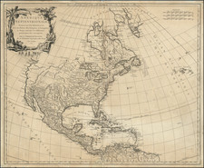
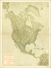
Beautiful and very rare map of North America, showing marvelous detail in the interior of the continent, especially in the region on either side of the Mississippi.
The map covers the entirety of North America, stretching from Labrador in the north to the northern coast of South America in the south, and includes the Caribbean region as well. An inset of the Canadian Arctic is located in the upper left corner of the map. The map was published during the French & Indian War and was compiled using the most recent and reliable geographical information available at the time.
The map includes interesting speculative information at the fringes of the Missouri River watershed and on the Canadian prairies.
The title of the map, "L'Amerique septentrionale, Dressee sur les Memoires le plus recensdes meilleures geographes & publiee par Covens & Mortier," translates to "North America, Drawn from the Most Recent Memoirs of the Best Geographers & Published by Covens & Mortier."
Rarity
This map is rare. We have handled it only one other time, two decades ago.
There is a second state of the map, circa 1783, in which the "XII ETATS UNIS" is named within the map.
Covens & Mortier was one of the largest and most successful publishing firms in Dutch history and continued in business for over a century. Pierre Mortier the Elder (1661-1711) had obtained a privilege in 1690 to distribute the works of French geographers in the Netherlands. After his widow continued the business for several years, Cornelis (1699-1783) took over in 1719.
In 1721, Mortier forged a partnership with Johannes Covens (1697-1774), who had recently married Cornelis’ sister. They published under the joint name of Covens & Mortier. In 1774, upon the death of his father, Johannes Covens II (1722-1794) took over his father’s share. In 1778, the company changed its name to J. Covens & Zoon, or J. Covens & Son.
Covens II’s son, Cornelis (1764-1825), later inherited the business and brought Petrus Mortier IV back into the fold. Petrus was the great-grandson of Petrus Mortier I. From 1794, the business was called Mortier, Covens & Zoon, or Mortier, Covens, & Son.
The business specialized in publishing French geographers including Deslisle, Jaillot, Janssonius, and Sanson. They also published atlases, for example a 1725 reissue of Frederik de Wit’s Atlas Major and an atlas, with additions, from the works of Guillaume Delisle. There were also Covens & Mortier pocket atlases and town atlases. The company profited from acquiring plates from other geographers as well. For example, the purchased Pieter van der Aa’s plates in 1730. Finally, they also compiled a few maps in house. At their height, they had the largest collection of geographic prints ever assembled in Amsterdam.