


|
||

|

|
|

|
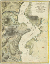
Sailing Chart for New York Harbor Used at Sea in the 1880s
Finely preserved separately published chart of the entrance to New York Harbor on thick paper, first published by the United States Coast and Geodetic Survey in 1875.
The chart extends from the south part of Brooklyn, Jamaica Bay and Staten Island in the north to Back Point and the Shrewsbury River in the south. The map includes beacons, lights and lighthouses, sailing directions, hundreds of soundings, and extensive pencil annotations used by one or more early navigators traveling through the channels in the harbor. On land, there is a significant amount of topographical detail, as well as the names of cities, forts, wharfs, rivers and the location of a number of coastal buildings and roads.
Updated with aids to navigation corrected to 1884, the map credits Edmunt Blunt for the Triangulation work (1855) and topographical details by a host of United States Naval officers between 1855 and 1882.
Above the title, two sweeping profile views are shown, covering the areas centered on Highland Lights and Sandy Hook.
The sailing directions include a note on the current and 4 sets of notes for channels:
- Gedney's and Main Channel
- South and Swash Channel
- False Hook Channel
- East Channel
At the far left, the coordinates for New York City Hall are shown along details on Tides, Currents, Lighthouses & Beacons, Light Vessels and Buoys.
The condition of this chart is quite good, considering its extensive use at sea.
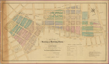
![[Upper East Side - Manhattan -- 79th Street to 93rd Street] Map of the Common Lands from 76th to 93rd Street Showing the Old Streets and Plots As Surveyed and Mapped in 1796, By Cassimer T. H. Goerck, City Surveyor and Resurveyed by Isaac T. Ludlam in 1822 (See Notes) And the Distance between those old Streets and our Present Streets Part 4](https://storage.googleapis.com/raremaps/img/small/61033.jpg)