


|
||

|

|
|

|
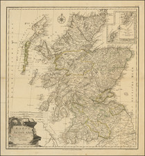
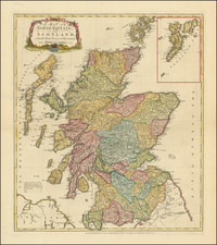
Finely executed large map of Scotland, published in Vienna by FA Schraembl.
The map is based upon James Dorret's map of Scotland, issued in 1750. Initially, Dorret was retained to survey and create a map Argyll for his then employer, the Duke of Argyll. The success of the project resulted in the expansion of the project to all of Scotland.
Dorret conducted his own survey work, relying also upon William Roy's Military Survey of Scotland (1747-1755), and current estate and maritime surveys.
The map was "an immense improvement on anything that preceded it" (Inglis et al. The islands of Skye and Lewis, are drawn with greater accuracy than any prior maps. The island of Lewis finally loses flat top present since Blaeu's maps of the early17th Century, which by Dorret's time had been corrected by the maritime charts of Murdoch Mackenzie.
Schraembl was born and worked in Vienna, where he was a mapmaker in the latter half of the eighteenth century. He began his business in 1787, partnering with Franz Johann Joseph von Reilly. He is best known for his large format atlas, the Allgemeiner Grosser Atlas. The atlas was finished in 1800, after twenty years of compilation and composition--it was the first Austrian world atlas. While a notable work, the atlas did not sell well, plunging Schraembl into financial difficulty. In response, Schraembl expanded his offerings to include literature and art. Upon his death, Schraembl's firm was taken over by his widow, Johanna, and her brother, Karl Robert Schindelmayer. From 1825, it was run by Franz Anton's son, Eduard.
![[ Edinburgh ] Edimbourg](https://storage.googleapis.com/raremaps/img/small/101956.jpg)