|
||

|

|
|

|
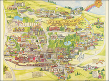
Jackson's Hole Wyoming, produced in 1968, offers a pictorial map of the region complemented by illustrated advertisements of businesses and events, encapsulating the essence of the area during a pivotal time in American history. This map presents Jackson Hole not merely as a geographic location but as a vibrant nexus of cultural, commercial, and recreational activities, projecting the charm of what was then known as "The Last of the Old West."
In the late 1960s, America witnessed significant social, cultural, and political shifts. Against this backdrop, places like Jackson Hole in Wyoming stood as sanctuaries, preserving the romanticized memory of the old American West. Such regions, often dubbed as the last bastions of a disappearing frontier, retained an aura of nostalgia even as modernity encroached upon them. The allure of Jackson Hole during this era was the delicate balance it maintained between tradition and progress, evident in its businesses and leisure activities.
The map's thematic inclusions, such as "DUDE TIPS," "WHERE TO STAY!," "WHERE TO GO!," and "WHAT TO DO!," underscore the tourism-centric vision of the region. These pointers, though seemingly casual, are significant markers of the local culture, catering to visitors looking for an authentic Western experience. This emphasis on "WESTERN FUN" also aligns with the broader American trend of the late 1960s, where rustic experiences were becoming increasingly commercialized and packaged for wider consumption.
Additionally, the map's visual advertisements shed light on the symbiotic relationship between Jackson Hole's natural landscapes and its commercial enterprises. They collectively narrate a story of a locale which, while cherishing its past, eagerly anticipated a future molded by tourism, recreation, and commercial endeavors. The juxtaposition of nature with commerce showcases a harmonious coexistence, highlighting the region's adaptability and resilience amidst evolving times.
![[ Idaho Below Montana ] Verein-Staaten am Stillen Ocean… [inset of San Francisco Bay] [Unusual Idaho & California configurations]](https://storage.googleapis.com/raremaps/img/small/99297.jpg)
![[Montana, Wyoming, Dakota, Upper Missouri River] Amer. Sep. No. 40. Partie des Etats Unis](https://storage.googleapis.com/raremaps/img/small/93546.jpg)