This item has been sold, but you can enter your email address to be notified if another example becomes available.


|
||

|

|
|

|
Stock# 90071
Description
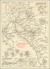
An unusual wall map presentation of this authoritative U.S.G.S. topographical map of Yosemite Valley, prepared by the Geological Survey and the State of California Department of Engineering. The surveying was done "in 1905-06 in cooperation with the State of California."
The map includes elevations of principal points such as El Captian, Half Dome, Glacier Point, Sentinel Hotel, etc. Most, if not all, of the famous landmarks in Yosemite are labeled.
The map was initially prepared in July 1907 and this example was printed in 1913.
Condition Description
Color-printed map on thin paper mounted on canvas and wooden dowels. The paper is fragile and flaking, namely next to the title (as illustrated), and at the edges. A few other cracks in the paper, namely coming from the top to the right of the title.
![(Yosemite Photographs) [Contemporary Album of 12 Albumen Photographs of Yosemite Valley] Views in California [binding title]](https://storage.googleapis.com/raremaps/img/small/94232.jpg)
![(Mammoth Plate Photograph) [View on the Merced, Yosemite]](https://storage.googleapis.com/raremaps/img/small/88250.jpg)