|
||

|

|
|

|
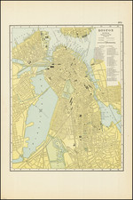
The First Large-Scale American Map of the Greater Boston Area.
Rare first edition of the Hales map of the greater Boston area.
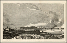
Hales's map is notable for being based on one of the first trigonometric surveys conducted in America and for being the first detailed map of greater Boston since the Des Barres chart forty-five years earlier. The map depicts the entirety of Boston Sound and reaches some fifteen miles inland of the city. In the far northeast, Salem Head is visible.
Boston is, of course, shown in exacting detail. Cambridge is mapped accurately with Harvard denoted and some campus buildings shown pictorially. The U.S. Arsenal in Watertown is shown. In the countryside, every building, farmhouse, forest, hill, and road is indicated. District boundaries are indicated. Turnpikes, swamps, hotels, churches, and much more are shown throughout.
The map includes a legend in the lower right. An imprint at the bottom of the map states that the map was published in Boston by John G. Hales and in Philadelphia by J. Melish.
History of Surveying in New England
Traditionally, much of the surveying in New England, with the exception of that conducted for the Atlantic Neptune, was executed in the "metes and bounds" method. This used a simple measuring chain continuously running along the line to be surveyed, while other information was added in by sight. While easy to execute, it was notably inaccurate.
Triangulation, which used more complex mathematics and instruments, had become prevalent in Europe since the middle of the 18th century, but failed to garner much traction in the New World. There is scant evidence that any American surveyor prior to Hales had attempted to use triangulation over such a wide area as shown on the present map, making this map a milestone in American cartographic surveying.
John Hales
Prior biographies regarding the life and cartographic output of John Hales have been relatively limited and summarized by the following quote:
"[Hales] appears in the Boston Directory for the first time in 1818, though he published his map of Boston in 1814. From one of his few surviving contemporaries, it is learned that he was an Englishman, duly educated in his employment, that he was a rapid, possibly a hasty, workman, and that his business career was not always satisfactory. He died in Boston of apoplexy, May 20th, 1832, aged 47 years, and was buried in St. Matthews Church (Episcopal) in South Boston." Maps of the Street Lines of Boston, (William Whitemore, ed.), 1894
However, recent research by Michael Buehler has greatly expanded our knowledge of Hales's life. By inspecting Hales's maps and other contemporary documents, he were able to recreate Hales's life story. Hales's early career was spent in England developing an expertise in turning salt marshes into agricultural or otherwise usable land, a skill that he later put to good use in Boston.
Around 1810, Hales emigrated to North America and settled in Portsmouth. He produced some town plans of Portsmouth in 1812 and 1813, and also made a map of the Seat of War regarding the War of 1812. In 1814, he produced his Map of Boston in the State of Massachusetts, which was, to date, the largest map of the city. It was also by far the most detailed map of the city yet issued.
Following this, Hales was engaged in several different projects including contributing to the 1816 Carrigain map of New Hampshire, for which he was remunerated by the state legislature. He issued the present map in 1819 and was then commissioned to produce an even larger-scale map of the city of Boston. That latter map remained in manuscript form until its 184 publication.
As early as 1820, Hales attempted to convince the Massachusetts State Legislature and other bodies to fund a new map of Massachusetts to replace the outdated and flawed Carleton map, first published in 1798. While many were supportive of his ideas, he failed to receive any funding. Funding for the project only came in 1830, but Hales was not selected to direct it. Fortunately, he did derive some work from individual cities that made smaller surveys in conjunction with the state-wide survey. Hales would die in 1832.
John Melish (1771-1822) was the most prominent American mapmaker of his generation, even though his cartographic career lasted only a decade. Melish was born in Scotland; he moved to the West Indies in 1798 and then to the United States in 1806. By 1811, he had settled in Philadelphia and published Travels through the United States of America, in the years 1806 & 1807, and 1809, 1810, & 1811, which was richly illustrated with maps.
Melish created several regional maps of the highest quality, as well as the Military & Topographical Atlas of the United States (Philadelphia, 1813, expanded 1815). The latter work is widely considered to be the finest cartographic publication to come out of the War of 1812.
By far his best-known work is his monumental map of the United States of 1816, Map of the United States with the contiguous British and Spanish Possessions. He began working on the map in 1815 and sent it to Thomas Jefferson for comment in 1816. Jefferson enthusiastically reviewed the map and returned it with his edits. Jefferson later hung an example of the map in the Entrance Hall of Monticello and sent it to associates in Europe.
Melish’s finished product was the first map of the United States to extend to the Pacific Ocean. After its publication in 1816, Melish ensured the map was as up-to-date as possible; it was reissued in 25 known states published between 1816 and 1823. The map captured the then rapidly changing geography of the United States, as well as various boundary disputes, treaties, and expansion.