|
||

|

|
|

|
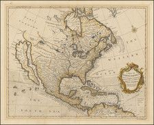
Very Rare English Edition of "The Earliest Geological Map of America" - Roy Porter
Rare English edition of Jean-Étienne Guettard and Philippe Buache's important map of North America (Carte Mineralogique ou l'on voit la Nature des Terreins du Canada et du Louisane), generally regarded as the first geological map of the continent and also published in 1756. This is the first English-language geological map of North America.
Cole's map appeared in the December 1756 edition of the Literary Magazine, a short-lived British periodical published by Dr. Samuel Johnson from 1756 to 1758. Like the Buache/Guettard map, it includes 39 symbols to show the locations of rocks, minerals, springs, and fossils between the Atlantic and the Rocky Mountains. It also shows three different geological strata (discussed further below), although they are unnamed on the map.
Among the other curious features on the map, the map is one of the earliest English depictions of the Sea of the West (Western Sea), a mythical inland sea stretching from the Pacific Ocean to the Rocky Mountains.
The oldest geological map of North America
Historians of science define the key criterion of a geological map as one which extrapolates the position of strata (rock types, or "earths" in this work) without having seen them at surface. This is in contrast to maps of resource distribution, which may show the positions of certain quarries or outcrops, but make no inference as to what lies between them. While earlier maps of North America do the latter, as in Lewis Evan's maps of 1749, 1751, and 1755, they make no claims to extrapolate the positions of rocks not seen at the surface. As such, Guettard and Buache's map, here copied by Cole is considered the oldest geological map of North America.
Cole's edition of the map shows, but does not name, the three rocky types that Guettard hypothesized. The darkest shading, just off the eastern coast of the continent is meant to represent a "sandy belt," the light grey coastal shading a "marly belt" and the unshaded interior of the continent a "schist-like metallic band." These are meant to cover, in order: sands, marls and sandstones from the continental shelf; limestones with no metal other than iron from coastal areas; and finally shales, slates, sandstones, schists, granites, etc. in inland areas poor in fossils but rich in metallic deposits and hot springs. While we now know that such strata are unlikely to represent cogenetic groupings, one could imagine where Guettard got this idea. His only resources for the offshore areas were Caribbean islands rich in sand and marl. Along the North American coast, limestones are very common, and fossils are abundant though ore deposits rare. Inland, orogenies and other processes have resulted in highly variable rock types, abundant ore deposits, and hot springs. In addition, the samples which Guettard worked with were limited and generally conformed to the above groupings when classed according to location. As this data seemed to match Guettard's theory of rock formation (discussed in the next paragraph) he extrapolated these bands to large areas in a way we now know to be incorrect.
This map includes representations of the theory of "Neptunism," now attributed to Abraham Werner, which seeks to explain the deposition of different rock types through a shrinking ocean. In this theory, a global ocean with a heterogeneous seafloor precipitated certain rocks at different stages. The differences in the three main periods of rocks deposited correspond to changing conditions of the ocean, which is taking to influence a wide variety of factors, such as the crystallinity of rocks or their fossil contents. Attributing this map to a version of that theory, the "metallic belt" would be from the primary (first) period, and represent the oldest rocks deposited during calm seas. The "marly belt" would represent a transitional (second) period, in which some of the properties of both the primary and the floetz (third) period are preserved. Floetz refers to the conditions of the modern oceans, responsible for the "sandy belt" and deposited in chaotic modern oceans.
In addition to the three bands of lithologies, the map shows the locations of 39 different types of rocks, ores, and geological processes. These reflect some key resources of the period, such as copper-bearing rocks, as well as more general observations, such as the location of hot springs.
Rarity
The map is extremely rare on the market. This is the second time we have offered the map for sale (previously offered in 2010), but we are unable to trace any other dealer or auction records for the map.
Both the Cole and the Buache/Guettard maps are rare, but the Cole English edition is significantly rarer due to the limited distribution of the Literary Magazine.
Many European maps of North America in the eighteenth century depict a large, western inland sea, hundreds of miles in diameter, with a small inlet to the Pacific and even some interior islands. The origins of this myth can be traced to several different sources and are tied to the search for a Northwest Passage. Like many cartographic myths, the Sea of the West persisted for decades, even in the face of strong evidence pointing to its non-existence.
One of the first European navigators to supposedly explore this area was Martin Aguilar. A Spanish captain, he sailed with Sebastian Vizcaino on a reconnaissance expedition up the California coast in 1602-3. Aguilar, commanding the Tres Reyes, was blown off course, to the north. When the seas calmed, Aguilar reported that he had found the mouth of a large river. Eighteenth-century geographers later conjectured that the river was the entrance to the Sea of the West.
Other maps placed the entrance to the Sea of the West via the Juan de Fuca Strait. Juan de la Fuca is the Castilianized name of Greek navigator Ioánnis Fokás (Phokás). Little archival evidence survives of Fuca’s career, but a chance meeting with an English financier, Michael Lok, in Venice in 1596 gave birth to rumors of Fuca’s voyages in the Pacific. Fuca reported that he had been sent north from New Spain twice in 1592 in search of the Strait of Anian. The Spanish Crown failed to reward Fuca’s discovery of an opening in the coast at roughly 47° N latitude and Fuca left the Spanish service embittered. His story lived on in Lok’s letters and eventually was published in Samuel Purchas’ travel collection of 1625. On many eighteenth-century maps, Fuca’s Strait is linked with a River or Sea of the West. In 1787, the present-day Juan de Fuca Strait was named by the wife of naval explorer Charles William Barkley, making permanent a label that had previously just been hopeful guesswork.
The source of the modern (18th Century) myth of the Sea or Bay of the West (Baye ou Mer de L'Ouest in French), are manuscript maps by Guillaume De L'Isle, who served as the Royal Geographer to the King of France at the end of the 17th Century and beginning of the 18th Century and is widely regarded as the most important map maker of his time. There is a map in Yale's map collection, which depicts a 16th Century Thames school map of North America with a large, "Branch of the South Sea," which closely resembles De L'Isle's Mer de L'Ouest, and may well be the source of De L'Isle's idea.
At the end of the 17th Century, Guillaume De L'Isle had access to the best available maps of the interior of North America, which were being provided from a number of missionary sources, as the French Missionaries pushed west of the Great Lakes and the Mississippi River and obtained information from the indigenous Indian tribes. De L'Isle was regularly producing and updating his manuscript maps in an attempt to integrate new and often conflicting information and improve upon the existing maps of North America. Many of his maps can be viewed as drafts, which were discarded in favor of other and considerably different models.
There are several De L'Isle manuscripts in the Bibliotheque Nationale de France, prepared as early as 1696 (dated), that depict this cartographic myth. Interestingly, while De L'Isle was a prolific publisher of printed maps, he never depicted the Sea or Bay of the West on any of his printed maps, which strongly suggests that he was not able to reconcile this information with the best available source information from America. During this same period, Jean Baptiste Nolin, who had in the prior decade collaborated with Vincenzo Maria Coronelli on his monumental globe for Louis XIV and produced a series of highly important maps of North America and its regions, would have also had access to many of the same reports and maps as De L'Isle. Nolin apparently gave greater credence to the concept than De L'Isle.
The earliest printed map to show the Bay of the West is Jean Baptiste Nolin's rare wall map of the world, published in about 1700. Nolin plagiarized the idea from Guillaume De L'Isle, as he testified when suing Nolin for plagiarism. He said, the Sea of the West “was one of my discoveries. But since it is not always appropriate to publish what one knows or what one thinks one knows, I have not had this sea engraved on the works that I made public, not wanting foreigners to profit from this discovery” (as quoted in Pedley, The Commerce of Cartography, 109). The court sided with De L'Isle and issued an order requiring Nolin to destroy the copper plates for the map (see Shirley 605). Nolin's map was in turn copied by the Mortier family, who issued 3 world maps shortly thereafter, showing Nolin's version of the Sea of the West, but the myth ignored for nearly half a century.
While the myth of the Sea or Bay of the West temporarily languished, the proliferation of Russian exploration off the Northwest Coast of America after 1740, as reported by Guillaume's younger brother Joseph Nicholas De L'Isle, reinvigorated interest in the region and forced the most prominent map makers of the period to re-examine existing knowledge. Joseph Nicolas served as a geographer to the Russian Academy and returned with this information to Paris. The re-introduction of the sea in the mid-eighteenth century was the result of Guillaume De L’Isle’s son-in-law, Philippe Buache’s review of his father-in-law’s papers. Although Guilluame De L’Isle never published a printed map showing the sea, he had postulated that it could exist, and that it might connect to a Northwest Passage through New France, not through English territory farther north.
The sea was a major part of Buache and Joseph-Nicholas Delisle’s maps of the North Pacific, published in the 1750s. While controversial, the features of those maps were quickly copied by other mapmakers, including the Sea of the West. The inland body of water lingered on maps until the later-eighteenth century.
During a period between 1750 and 1770, the most prominent French and British map makers advanced multiple and widely varying theories on the Northwest Coast of America. Denis Diderot dedicates several of the 10 maps in his monumental Encylopedie (1779 and after), to a comprehensive survey of the maps proffered by Joseph Nicholas De L'Isle (Guillaume's brother), Philippe Buache, Thomas Jefferys and others. The debate ended with Captain James Cook's and later George Vancouver and Comte Jean de la Perouse's explorations in the late 18th Century.
Notes on the earliest geological maps of the United States (Wells)
From Mineralogy to Geology: The Foundations of a Science, 1650-1830 (Section 5, Lauden)