|
||

|

|
|

|
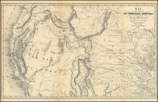
The Wishbone Route at Denver, a striking folding color lithographed bird's-eye view from circa 1907, offers a vivid depiction of the rail route from Denver towards Leyden and Golden in Colorado, with prominent peaks including Pikes Peak, Greys Peak, Mount Evans, and Longs Peak, in the background. The map's perspective allows a unique view of Clear Creek and Ralston Creek, following each of the two legs of the "Wishbone Route," reflecting the promise of luxury, ease, comfort, and speed.
The early 20th century was a time of significant growth and development in Denver, with the expansion of rail networks playing a crucial role in connecting the city to its picturesque surroundings. The Wishbone Route, offering a comfortable journey without the challenges of mountain climbing, smoke, or cinders, was a symbol of this modern connectivity. The use of parlor electric observation cars highlights the technological advancements of the era and a growing emphasis on passenger comfort.
This lithograph, produced by The Denver Lithograph Company, serves as an artistic and commercial object, illustrating not just the physical geography but also the burgeoning tourist industry in Denver and the broader Colorado region. The alignment of the route, as well as the detailed rendering of the landscape and key landmarks, provides valuable geographical insights.
Moreover, the historical context of the rail system at this time underscores the importance of transportation in shaping the socio-economic fabric of the area. Railways such as the Wishbone Route facilitated both local travel and the attraction of visitors, contributing to the economic vitality and cultural appeal of Denver.
The map's colorful lithography and bird's-eye view perspective add to its appeal, capturing the allure of the landscape and the promise of a luxurious journey. It stands as a testament to the intersection of geography, technology, and commerce in early 20th-century Denver, reflecting a period of optimism, growth, and connection.
![[ Colorado ]](https://storage.googleapis.com/raremaps/img/small/88749.jpg)