


|
||

|

|
|

|
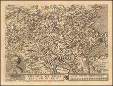
Rare Hugo Allard Map of the Turkish Empire
Rare map of the Turkish Empire by Hugo Allard (1630-1685).
A fine depiction of the Ottoman Empire on the eve of the Great Turkish War (1683-1699), which marked a turning point in the fortunes of the empire and that of Europe. Up to the 1680s, the European Christian powers of Habsburg, Austria, Russia, Poland-Lithuania and the Republic of Venice, had separately fought the Ottoman Empire in numerous wars over the last century only to arrive at a stalemate. The Turks had largely kept the great gains they had made during the reign of Suleiman the Magnificent (ruled 1520-66), in spite of innumerable attempts by the Christian powers to dislodge them. The line of control generally ran through Croatia, the middle of Hungary and northern Romania, to what is now Moldova, with the Ottoman lands being to the south of the line.
In 1683, an Ottoman army broke out of Hungary to besiege Vienna, the Habsburg capital. This sent a shockwave throughout Europe, and only the intervention of Poland's King Jan Sobieski saved the city. In 1684, the region's main Christian powers formed the Holy League, marking the first time that they all joined forces to fight the Ottomans. This quickly turned the tables, as the Allies inflicted a series of severe defeats on the Turks. The Second Battle of Mohács (1687), restored all of Hungary to the Habsburgs. The decisive showdown of the war was the Battle of Zenta (1697) in Serbia, whereby an Allied force under Prince Eugene of Savoy, crushed the main army of the Ottoman, Sultan Mustafa II.
The Turks sued for peace and the war was concluded at the Treaty of Karlowitz (1699). By the treaty, Austria won all of Hungary, areas in the Balkans and Transylvania; Poland-Lithuania regained Podolia; Russia acquired the key Black Sea port of Azov and Venice acquired Morea and inner Dalmatia. The war was highly consequential in the long run in that it signaled the beginning of a progressive decline in the size and influence of the Ottoman Empire.
The map is embellished with a decorative cartouche, featuring figures in elaborate Turkish costumes.
Rarity
The map is very rare. This is the first example we have ever seen on the market.
Carel (Carol) Allard (Allardt) (1648–1709) was an engraver and publisher based in Amsterdam. Part of a prominent family of Dutch mapmakers, publishers, and print sellers, his father was engraver and publisher Hugo Allard (1627–1684), who left his business to Carel upon his death. Carel published anything in demand, including maps, topography, ethnography, newsprints, and restrikes of old plates of artistic prints, many of which likely came from his father’s stock. In 1706, Carel gave his copperplates to his son Abraham Allard, before going bankrupt.
![A New Map of Turkey In Asia, Divided into its Provinces . . . 1801 [Cyprus]](https://storage.googleapis.com/raremaps/img/small/71232.jpg)
![[ Arabian Peninsula ] Tabula VI Asiae](https://storage.googleapis.com/raremaps/img/small/95796.jpg)