|
||

|

|
|

|
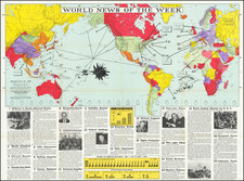
A frightening example of cartographic propaganda, showing an expanding Germany just before the outset of the Second World War in Germany.
The map shows a Germany that has swelled in size to encompass Austria and the Sudetenland while placing the Czech Republic and Danzig under its "protectorate." Slovakia is further shown as being under German influence. The map lists the growth of the German population and area between 1933 and 1939.
This rare map was published by the Deutscher Verlag publishing house in Berlin.
This example of the map has numerous manuscript annotations, including underlining of many cities and lines connecting various metropolises. The exact purpose of these annotations is unclear, although they may represent major railroad connections of the day.
![Gibraltar to Berlin. [World War II Broadside Map.]](https://storage.googleapis.com/raremaps/img/small/83480.jpg)
![[ Holy Roman Empire ] Germania, Non ea tantum quae Rheno, Vistula, Danubio, mariqz Germanico Veteribus claudebatur; Sed tota illa continens quae hodie communiter Germanica lingua utitur . . .](https://storage.googleapis.com/raremaps/img/small/99236.jpg)