All of our maps are authentic antique maps, printed or drawn on or about the date shown in the description. In rare instances when we offer facsimiles, we will specifically describe the map as a later facsimile and include the date of publication. Certificates of Authenticity are included with each item.
Map Maker
Fast, Global Shipping
Last year we shipped over 4,500 antique maps to more than 50 countries. Maps are shipped Monday through Friday year-round. If an order is received before 2 PM PST, we will ship the order that day. If an order is received after that time, we will ship the next day. We ship maps either flat in custom packages or in specially ordered thick tubes. Shipping rates are provided as part of the checkout process.
Description
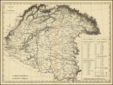
Detailed map of a portion of Western Hungary.
The map tracks the course of the Danube, with Budapest at the center. Balaton Lake, one of Europe's largest lakes, appears at the the left.
A number of post roads are shown, connecting major cities.


![Carte de la Hongrie et des Pays qui en dependoient autresois dressée sur un grand nombre de memoire. . . 1703 [Map of Hungary and the countries that used to depend on it, previously drawn from a large number of records... 1703.]](https://storage.googleapis.com/raremaps/img/small/93871.jpg)
![(Central Europe and Hungary) Ungria Restaurada compendiosa noticia, de dos tiempos: del Passado. Baxo el Jugo de la Tirania Othomana, del Presente, Baxo el Dominio Catholico de Leopoldo II de Austria. [Hungary Restored, Extensive Notices about].](https://storage.googleapis.com/raremaps/img/small/68278.jpg)