|
||

|

|
|

|
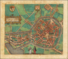
Fine original color example of this view map of Staveren (modern-day Stavoren) by the renowned Dutch cartographer Blaeu, which first appeared in his Novum Ac Magnum Theatrum Urbium Belgicae Liberae Ac Foederatae.
The map showcases the intricate layout of Staveren, a prominent town in Friesland, the Netherlands, during the 17th century.
The city's fortifications and defenses are prominently displayed, including its walls and bastions that surround the town. Inside these fortifications, the map depicts the town's streets, churches, and buildings in a detailed manner, highlighting the architectural style of the era. The harbor area, along with its docks, ships, and maritime activities, are also clearly illustrated, reflecting the city's strategic location on the shores of the Zuider Zee (modern-day IJsselmeer).
Additionally, the map includes decorative elements, such as two coats of arms, representing the city and its governing entities. One coat of arms appears in the upper right corner, while another appears in the upper left, along with a cartouche in the upper center, identifying the map as a city view of Staveren.
The city layout and maritime features on the map reflect Staveren's historical significance as a trading port and its role in the region's economic and cultural landscape. The presence of key landmarks, such as churches and administrative buildings, further emphasizes its standing within Friesland and beyond.
Joan, or Johannes, Blaeu (1596-1673) was the son of Willem Janszoon Blaeu. He inherited his father’s meticulous and striking mapmaking style and continued the Blaeu workshop until it burned in 1672. Initially, Joan trained as a lawyer, but he decided to join his father’s business rather than practice.
After his father’s death in 1638, Joan and his brother, Cornelis, took over their father’s shop and Joan took on his work as hydrographer to the Dutch East India Company. Joan brought out many important works, including Nova et Accuratissima Terrarum Orbis Tabula, a world map to commemorate the Peace of Westphalia which brought news of Abel Tasman’s voyages in the Pacific to the attention of Europe. This map was used as a template for the world map set in the floor of the Amsterdam Town Hall, the Groote Burger-Zaal, in 1655.
Joan also modified and greatly expanded his father’s Atlas novus, first published in 1635. All the while, Joan was honing his own atlas. He published the Atlas maior between 1662 and 1672. It is one of the most sought-after atlases by collectors and institutions today due to the attention to the detail, quality, and beauty of the maps. He is also known for his town plans and wall maps of the continents. Joan’s productivity slammed to a halt in 1672, when a fire completely destroyed his workshop and stock. Joan died a year later and is buried in the Westerkerk in Amsterdam.
![[Delft]. Delphium urbs Hollandiae cultissima, ab eiusdem nominis fossa vulgo, Deelft appellata](https://storage.googleapis.com/raremaps/img/small/54931mp2.jpg)