|
||

|

|
|

|
Tracing the Coast of Australia for Settlement
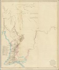
Detailed map of the southern coast of Australia, part of a series of maps John Arrowsmith prepared in the 1840s to promote the settlement of South Australia. It was included in a dossier of maps that was put before Parliament as they were discussing the settlement of the new colony.
The map stretches from Adelaide and Encounter Bay in the east to King George’s Sound in the west.
Along the coast are several toponyms that point to early European voyages. For example, Nuyts Archipelago references the first known European ship in the area, Pieter Nuyts’ Gulden Seepaert in 1627. Archipelago of the Recherche references the ship, the Recherche, of Antoine Raymond Joseph de Bruni, chevalier d'Entrecasteaux. D’Entrecasteux and his crew skirted the coastline in 1792, in search of fellow French explorer, La Perouse.
Another note nearby says that a bay was “not included in Flinders chart” and, to the east, are several spots named for the Investigator. This is the ship and chart of Matthew Flinders, who circumnavigated Australia in 1801-1803.
The emphasis of the map is on the shore itself and on the track to Lake Torrens, which was traversed by Edward John Eyre from 1839-1841. Eyre set out for both locales from Adelaide with a dray, or cart (dotted line), and eventually continued on horseback (solid lines). As shown here, Eyre’s attempt to get to the interior was thwarted by the confusing Lake Torrens (1839-1840). Eyre also traveled overland in 1840-1, hugging the coastline, from Adelaide to King George’s Sound.
Eyre’s inland attempt fed an ongoing geographic debate, namely that Australia should have an inland sea or water system, similar to other continents. Indeed, there are large lakes in southern Australia, but they are typically empty, except in times of intense rainfall. Eyre named the lake he found for Colonel Robert Torrens, one of the founders of the colony. The largest ephemeral lake in Australia is now named for Eyre himself, as he sighted it. When full, it is the largest lake in Australia (9,500 square kilometers), although the water is saline.
As the many narratives notes on this map indicate, it was dawning on settlers that the interior of Australia was dry and arid. The most frequent of the notes, which are taken from Eyre’s journals, reflect the search for, and failure to find, fresh water.
This map was included in a dossier of maps that was included in a Select Committee report from the House of Commons to the House of Lords.
Exploration of Southern Australia to 1820
Indigenous peoples have lived in Australia for 40,000 years. As was common with maps and charts of the nineteenth (and earlier) centuries, their presence is barely recognized here.
The first Europeans to contact southern Australia were the Dutch. En route to the East Indies, many Dutch traders decided to brave the fierce winds of the Roarin’ Forties (latitude) to speed their journey. However, this gamble sometimes resulted in being blown too far, onto an unknown (to Europeans) shore. While these first encounters, with the west coast, were largely accidental, later voyages sought to see what the continent had to offer.
The first European associated with southern Australia was Pieter Nuyts. Nuyts was an employee of the Dutch East India Company (VOC). In the Gulden Seepaert (Golden Seahorse), and captained by Francois Thijssen, Nuyts sailed nearly 800 nautical miles along the southern coast in 1627, reaching present-day Ceduna. As the highest-ranking officer on board, the land was named for him, Land van Pieter Nuyts.
By the end of the seventeenth century, the VOC had largely abandoned the idea of a colony or outpost in Australia. By the turn of the eighteenth century, in contrast, all of Australia was hotly contested by both France and Britain; the latter had already established their penal colony in eastern Australia. In 1801, the French ships Géographe and Naturaliste, under the command of Nicolas Baudin and Emmanuel Hamelin, surveyed much of the coastline.
Louis-Claude de Freycinet was the main hydrographer on the Baudin voyage who oversaw the publication of its account and atlas. Freycinet and the Baudin expedition were charting Western Australia at the same time a British expedition, under the command of Matthew Flinders, was doing the same; Flinders’ would eventually complete the first circumnavigation of Australia. He was detained by the French, however, and delayed in publishing his findings. Louis de Freycinet returned in command of his own expedition in 1818.
The early exploration and settlement of South Australia
Inland exploration of South Australia began in earnest only two decades prior to this map’s production. In 1819, a sealing captain named George Sutherland crossed Kangaroo Island on foot. Ten years later, from 1828-30, Charles Sturt traveled upriver on several voyages, locating the Darling and following the River Murray to its mouth. The surrounding area was fertile and led many to see South Australia as a viable new colony.
South Australia was officially proclaimed a colony in 1836, with the new planned settlement of Adelaide as its capital. Its location was decided thanks to a route from the Murray to Gulf St. Vincent, which was blazed by Collet Barker in 1831. Barker would be the first Surveyor General of South Australia. From 1836 to 1844, other explorers sought more information about the inland areas, including Johann Menge, who conducted geological investigations, and Robert Cock, who led several trips to find resources. Joseph Hawdon and Charles Bonney traced the Murray corridor in 1838; Bonney continued on the Coorong the following year.
In 1839, Charles Edward Frome was appointed Surveyor General of South Australia. Frome was a trained soldier who served in the Royal Engineers. He proved adept at surveying and wrote a text on the subject that ran to four editions. Frome suggested that Thomas Burr be named his Deputy.
Burr traveled to Australia, arriving in December 1839 to find that Governor George Gawler had also appointed a Deputy, B. T. Finniss. Perhaps to prove himself, Burr threw himself into the work, embarking on an expedition with Gawler and John Hill to be the first Europeans to probe the east coast of the Eyre Peninsula. Hill and Burr then charted the northern Yorke Peninsula. He led several later expeditions as well.
Edward John Eyre, the main subject of this map, led an expedition in 1839 to Mount Arden and the Flinders Ranges. Via Adelaide and Port Lincoln, he sought an overland route westward over the Eyre Peninsula. Then, in 1840, he led the first official expedition to uncover the secrets of the interior, although he was thwarted by Lake Torrens, which Eyre named. He followed this the following year with a coastal journey.
Frome continued to survey the lands that the commissioners of South Australia had sold, as settlers wanted to start their farms and ranches. He also led several expeditions, including an 1843 venture that named Lake Frome.
These trips found that, only a little way into the interior, the climate turned arid and the land dry. Combined with the later 1844 expedition of George Grey these sorties delimited the fertile “island” of South Australia.
The Arrowsmiths were a cartographic dynasty which operated from the late-eighteenth century to the mid-nineteenth. The family business was founded by Aaron Arrowsmith (1750-1823), who was renowned for carefully prepared and meticulously updated maps, globes, and charts. He created many maps that covered multiple sheets and which were massive in total size. His spare yet exacting style was recognized around the world and mapmakers from other countries, especially the young country of the United States, sought his maps and charts as exemplars for their own work.
Aaron Arrowsmith was born in County Durham in 1750. He came to London for work around 1770, where he found employment as a surveyor for the city’s mapmakers. By 1790, he had set up his own shop which specialized in general charts. Arrowsmith had five premises in his career, most of which were located on or near Soho Square, a neighborhood the led him to rub shoulders with the likes of Joseph Banks, the naturalist, and Matthew Flinders, the hydrographer.
Through his business ties and employment at the Hydrographic Office, Arrowsmith made other important relationships with Alexander Dalrymple, the Hudson’s Bay Company, and others entities. In 1810 he became Hydrographer to the Prince of Wales and, in 1820, Hydrographer to the King.
Aaron Arrowsmith died in 1823, whereby the business and title of Hydrographer to the King passed to his sons, Aaron and Samuel, and, later, his nephew, John. Aaron Jr. (1802-1854) was a founder member of the Royal Geographical Society (RGS) and left the family business in 1832; instead, he enrolled at Oxford to study to become a minister. Samuel (1805-1839) joined Aaron as a partner in the business and they traded together until Aaron left for the ministry. Samuel died at age 34 in 1839; his brother presided over his funeral. The remaining stock and copper plates were bought at auction by John Arrowsmith, their cousin.
John (1790-1873) operated his own independent business after his uncle, Aaron Arrowsmith Sr., died. After 1839, John moved into the Soho premises of his uncle and cousins. John enjoyed considerable recognition in the geography and exploration community. Like Aaron Jr., John was a founder member of the RGS and would serve as its unofficial cartographer for 43 years. Several geographical features in Australia and Canada are named after him. He carried the title Hydrographer to Queen Victoria. He died in 1873 and the majority of his stock was eventually bought by Edward Stanford, who co-founded Stanford’s map shop, which is still open in Covent Garden, London today.
![Australia [Black Swan]](https://storage.googleapis.com/raremaps/img/small/74287.jpg)
![Representation du Cours ordinaire des Vents de Traverse qui regnent les Cotes dans la grande Mer Du Sud [California as an Island]](https://storage.googleapis.com/raremaps/img/small/54744.jpg)