
This item has been sold, but you can enter your email address to be notified if another example becomes available.


|
||

|

|
|

|
Stock# 89186
Description
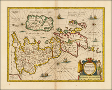
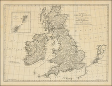
Gerard Mercator's Ptolemaic Map of Great Britain.
A beautiful example of this early edition of Mercator's map of the British Isles, from the 1584 edition of his Tabulae Geographicae, the first atlas published by Mercator.
Shirley notes that the Tabulae Geographicae was the earliest part of Mercator's lifelong plan to describe the whole of the ancient and modern world both geographically and historically.
The ancient map of the British Isles was finely drawn and engraved by Mercator himself. The towns and cities are named and shown with symbols which by then had become generally accepted. On the verso is an explanation of how the map has been converted from Ptolemy's projection to that used by Mercator.
Reference
Shirley 123.
![(British Isles) Tabu Moder Anglie & Hiber [Modern Map of England and Ireland]](https://storage.googleapis.com/raremaps/img/small/103164.jpg)