|
||

|

|
|

|
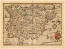
Striking Map of the Ancient Iberian Peninsula, with Inset of Cadiz. Separately Published Example.
Beautiful and detailed map of ancient Spain, Portugal and the Balearic Islands.
Oriented northward, this map displays the Iberian Peninsula, from the southern border of France (Galliae Confinia) in the northeast to the northern tip of Morocco (Africae pars) in the south. The peninsula is comprised of the three Roman provinces of Tarraconensis et Citerior, Lusitania, and Baetica, territory that covers modern-day Spain, Portugal, and the Balearic Islands.
This map is characterized by excellent attention to detail. The shape of the coastline is very accurate, which is unsurprising given that Europe was well mapped by this time. Rivers are carefully rendered, and throughout the map mountain ranges and forests give the land texture. In particular, the Pyrenees Mountains (Pyrenaei montes) dividing Spain and France are well-drawn. Cities are represented with precise drawings of buildings, which is typical of Ortelius maps.
Three strapwork cartouches adorn this map. In the northwest corner, a relatively simple cartouche indicates the title and cartographer. A more intricate cartouche in the southwest corner dedicates the map to the knowledgeable Spanish theologist Benedictus Arias Montanus, a personal friend of Ortelius. This one is more ornate than the last, containing figures in addition to the beautiful strapwork.
The third, and largest, cartouche contains an inset map of the Cadiz region, the southern tip of the peninsula at the Strait of Gibraltar. This additional detail shows more towns and a more precise coastline than the main map. The cartouche also contains an extensive list of places of unknown location, including peoples, cities, mountains, rivers, and more. All of the cartouches employ texture and shading which give them a three-dimensional appearance.
Each aspect of the map is labeled, and some labels give additional information about the name or events that occurred there. For example, the Strait of Gibraltar (Fretum Herculeum, Gaditanum, et Columnarum) is given a description that indicates it is the connection between the Mediterranean Sea and the Atlantic Ocean. Names of a variety of mythical and historical figures can also be found on the map, such as classical gods like Mercury and Diana, heroes like Hercules, and scholars like Pliny. This indicates the map’s use as a reference for the region in both geography and history.
Jan Janssonius (also known as Johann or Jan Jansson or Janszoon) (1588-1664) was a renowned geographer and publisher of the seventeenth century, when the Dutch dominated map publishing in Europe. Born in Arnhem, Jan was first exposed to the trade via his father, who was also a bookseller and publisher. In 1612, Jan married the daughter of Jodocus Hondius, who was also a prominent mapmaker and seller. Jonssonius’ first maps date from 1616.
In the 1630s, Janssonius worked with his brother-in-law, Henricus Hondius. Their most successful venture was to reissue the Mercator-Hondius atlas. Jodocus Hondius had acquired the plates to the Mercator atlas, first published in 1595, and added 36 additional maps. After Hondius died in 1612, Henricus took over publication; Janssonius joined the venture in 1633. Eventually, the atlas was renamed the Atlas Novus and then the Atlas Major, by which time it had expanded to eleven volumes. Janssonius is also well known for his volume of English county maps, published in 1646.
Janssonius died in Amsterdam in 1664. His son-in-law, Johannes van Waesbergen, took over his business. Eventually, many of Janssonius’ plates were sold to Gerard Valck and Pieter Schenk, who added their names and continued to reissue the maps.
![Les Estats de la Couronne d'Arragon en Espagne ou sont l'Arragon Royaume, la Catalogne Princip[au]té, la Valence Royaume, et les Isles de Maiorque... 1653](https://storage.googleapis.com/raremaps/img/small/80239.jpg)