|
||

|

|
|

|
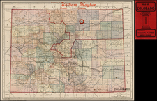
Fine example of this detailed map of Colorado, which offers a clear and detailed representation of the state during a period of notable expansion and industry. Published during a significant era for Colorado, this map offers a look into a time when mining in Southwestern Colorado was experiencing a revival.
Outlined in discernible colors, the map can be dated by the presence of Logan and Washington County, both established in 1887, find their place on this map, while the yet-to-be-formed Morgan County (1889), is absent. The map's hachuring technique effectively portrays the state’s topographical features, offering a clear representation of the mountain ranges, valleys, and other landforms. This method brings out the rugged nature of Colorado's landscape, from its towering peaks to its deep valleys.
The presence of rivers, creeks, and important towns is meticulously marked, with county seats being highlighted for emphasis. However, it is the early railroads, like the Denver & Pacific Railway and the Colorado Central Railroad, that catch immediate attention, showcasing the state’s developing transportation infrastructure. Of these, the Denver & Rio Grande Railroad's extension to Silverton stands out, reflecting the industry's growth in the region.
The southwestern region of Colorado, which encapsulates areas around Ouray County, San Juan Counties, and Telluride, holds a significant position not only on the map but also in the history of the state's mining industry. Starting in the 1870s, Southwestern Colorado began to gain attention for its rich mineral deposits. Initial discoveries of silver and gold veins led to a rush of prospectors and miners to the area. This wasn’t merely a transient influx; it marked the beginning of an industry that would define the region for decades.
The mining boom was catalyzed by several factors. Rich ore deposits, particularly in the San Juan Mountains, promised vast wealth. The establishment of the San Juan mining district in the early 1870s laid down a regulatory foundation that attracted both independent miners and mining companies. Towns like Silverton, Ouray, and Telluride began as small camps but quickly expanded into bustling hubs of activity, serving as commercial and social centers for the surrounding mines.
By the time this 1887 map was crafted, the mining industry had firmly entrenched itself in the region. The Denver & Rio Grande Railroad's extension to Silverton, prominently marked on the map, symbolizes the commitment to harnessing the region's mineral wealth. This railway line facilitated the movement of ore to distant markets and brought in essential supplies, making large-scale mining operations viable.
![Indian Territory [with Colorado on verso]](https://storage.googleapis.com/raremaps/img/small/74706.jpg)
![Location Map Mesa Verde National Park and the Scenic Southern Highways Across the Rockies [on sheet with:] Pictorial Guide to the Center of Activities in Mesa Verde](https://storage.googleapis.com/raremaps/img/small/93996.jpg)
![[ Early Western Automobile Road Map ] Goodrich Road Map of Arizona - Colorado - New Mexico - Utah](https://storage.googleapis.com/raremaps/img/small/101927.jpg)