|
||

|

|
|

|
Spanish Contact with Hawai'i Before Cook
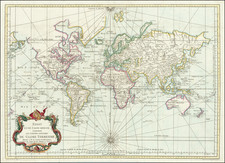
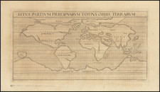
Rare and striking, separately-issued map of the world, first published by Spain's greatest eighteenth-century mapmaker, Tomás Lopez, in Madrid in 1771. This is a fine 1792 updated reissue.
Lopez's map is of significant historical interest as an artifact in the story of "Spanish Hawai'i," or of European contact with Hawai’i before the third voyage of James Cook (1776-1780).
The work is characteristic of Lopez’s erudition and craftsmanship and was published at a time when Spain was beginning to more actively publish their archive of information about the South Seas. Previously, they had treated the Pacific as a mare clausum, or closed sea, in the hopes that imperial rivals would not interfere with their trade and colonies.
The map provides a detailed charting of the world, and especially the Pacific Ocean, as known to the Spanish in the late-eighteenth century. Alaska has been updated based on Cook’s third voyage, but the northern coast of North America still holds its secrets, as does the delineation of Greenland. Australia is outlined, but with Van Diemen’s Land connecting to the mainland, as the Bass Strait would not be traversed by Europeans until 1798-9.
In the tradition of Lopez's training in Paris by J.B.B. D'Anville and others, the map is presented in a spare and precise fashion, jettisoning any information that could be skewed as mythical or without foundation. For example, there is no southern continent hypothesized, and the farthest south reached by Cook on his second voyage (1772-5) is marked.
There is, however, extra information outside the map’s boundaries, including the solar systems of Ptolemy, Copernicus, and Tycho Brahe. The ornamentation is reserved for the grand title cartouche running along the top, and the medallion hanging between the hemispheres.
Indeed, in the areas where the information set forth is based upon less-than-solid reports, language of caution and explanation are included. In several places, where reports deemed credible existed, but had not been established with certainty, Lopez reports "lands discovered" by explorers, including:
- "Tierras é Islas descubiertas por Mendana" (this is the supposed "Spanish Hawai'i" (see below) and is engraved across the top of the Islas Sandwich)
- "Tierras é Islas descubiertas por Quiros" (south of the Marquesas)
- "Tierra que vio Drake" (west of the Strait of Magellan)
- "Islas descubiertas por los Españoles en 1773" (west of Chile)
The aforementioned discoveries include two famous, early, but still unconfirmed, discoveries in the South Pacific by Francis Drake and Pedro Fernández de Quiros. The former supposedly sighted land while blown south after exiting the Strait of Magellan during his circumnavigation of 1577 to 1580. The latter, Quiros, had sailed with Mendaña on his second voyage (1595-1596) and became an advocate for a southern continent. He was granted his own voyage in 1605 and thought he discovered the continent; however, in actuality it was the island of Vanuatu. The voyage of 1773 was part of a series of four Spanish voyages (1771-1776) that set out in response to the voyages of Byron, Wallis, Carteret, Cook, and Bougainville in the 1760s.
Near to this final note is “Pascua ó Davis.” This is a clever elision of a rumored encounter and a documented one. In 1687, the buccaneer Edward Davis reported that he saw land in the area. In 1722, a Dutch voyage commanded by Jacob Roggeveen landed at Rapa Nui on Easter Sunday, giving the island another name of Easter Island (Pascua in Spanish). His crew were the first known Europeans to see the famed moai.
Lopez's location of the lands discovered by Mendaña are worthy of closer study in the context of the claims that the Spanish beat the British to Hawai'i in the sixteenth-century. These claims interestingly point to Alvaro de Mendaña as the commander who first encountered the island(s) in question, rather than the traditional sources of Villalobos (1542) or Gaetano (1555).
The alleged Spanish encounter with Hawai'i before Cook
A feature long overlooked by scholars, in part because of the rarity of this map, is the small section of land along the Tropic of Cancer identified as "Tierras e Islas descubiertas por Mendana". In the first version of the map, dated 1771, the note says, “Tierra descubierta por Medana” with a partial eastern coastline—the Sandwich Islands, of course, had not been named at that earlier date.
The note on this map is the earliest to memorialize the location of what many believe to be the sixteenth-century Spanish encounter with Hawai’i in the same place where Cook would come upon the Hawaiian Islands two hundred years later.
While the details supporting Spain's discovery of Hawai’i are far from clear, numerous researchers have discussed the possibility for well over one hundred years. The modern theories can be traced to a map captured by Commodore George Anson in 1743, which located an island group that corresponded with the location of Hawai'i. In the 1780s, La Perouse put forth the theory that Juan Gaetano discovered the Hawaiian Islands in 1555. There is also Spanish correspondence from the mid-nineteenth century which articulates the claim that Spain had found Hawai'i in the mid-sixteenth century.
The topic became a popular one for further scholarly discussion. For example, in the Bulletin of the American Geographical Society, Titus Munson Coan wrote:
The Hawaiian Islands were discovered in the year 1542 by the Spanish Navigator Juan Gaetano. Traces of this early visit may be found in a Spanish [manuscript] map of the sixteenth century which indicates the place of the islands, though somewhat incorrectly as to their longitude . . . (The Hawaiian Islands . . . Vol. XXI, No. 1889, p. 149)
The Spanish encounter with Hawai'i was reported as probable in other journals published over the next several decades. In Science (November 7, 1903), John F. Hayford published an article entitled "The Longitude of Honolulu, Various Determinations, 1555-1903," where he commemorated the first Trans-Pacific cable signal to reach Hawai'i with this survey, drawn largely from the work of Hawai'i's Surveyor General, W.D. Alexander. Hayford reports the acquisition by Anson in 1743 of a Spanish chart wherein:
a group of islands was laid down in the same latitude as the Hawaiian Islands, but 17º too far east. . . .[and that] an official letter from the Spanish Hydrographical Department to the Hawaiian Government dated Madrid, February 21, 1865, states that an ancient manuscript chart exists in the archives of that office, in which this group is laid down as in the chart of the Spanish galleon, with the name "Islas de Mesa," and a note declaring that they were discovered and named by Juan Gaetano in 1555.
Prior to Cook, there is certainly some evidence to support the encounter with Hawai'i by Spanish explorers in the mid-sixteenth century. The most compelling evidence supports the theory that Juan Gaetano, a Spanish navigator, visited Hawai'i in either 1542 (with Villalobos) or 1555. It is beyond question that Spanish ships were passing within a few hundred miles of Hawai'i during this period, as they regularly sailed between Latin America and East Asia.
Interest in this topic reached its height in the early 1900s. In 1900, Professor William Alexander wrote, "There is little doubt that these islands were discovered by the Spanish navigator, Juan Gaetano, in the year 1555." As noted above, Alexander was citing a document issued in February 1865 from the Colonial Office at Madrid, Spain and addressed to the Governor of the Philippines, which explains:
By all the documents that have been examined, it is demonstrated that the discovery [of Hawaii] dates from the year 1555 and that the discoverer was Juan Gaetano or Gaytan. The principal proof is an old manuscript chart, registered in these archives as anonymous, and in which the Sandwich Islands are laid down under that name, but which also contains a note declaring that he called them Islas de Mesa (Table Islands). There are besides other islands situated in the same latitude, but 10 degrees farther east and respectively named La Mesa, La Desgraciade, Olloa or Los Monges. The chart appears to be a copy of that called the chart of the Spanish Galleon, existing long before the time of Cook, and which is referred to by all the national and foreign authors that have been consulted. Foreign authors say that It (the discovery) took place in 1542, in the expedition commanded by General Rui Lopez de Villalobos, while the Spanish chronicles denote 1555.
Two island groups, called Los Monges and Los Bolcanos, appear on many maps of the sixteenth, seventeenth and eighteenth centuries, and may represent the Hawaiian archipelago, according to historian Father Reginald Yzendoorn. Writing in the 1920s, he notes:
The Los Bolcanos group, consisting of five islands, one of which is called Farfana (probably a misreading for La Tartana), appears for the first time in 1569 on Mercator's map: Nova et aucta orbis descriptio at between 22 and 26 degrees north latitude and about 176 degrees west longitude.
Los Monges are mapped for the first time by Abraham Ortelius on the map of America, made in 1587, and reproduced in the 1612 edition of his monumental atlas: Theatrum Orbis Terrarum. There they are at between 20 and 22 degrees north latitude and 159 and 162 degrees west longitude. Various cartographers during the two following centuries have maintained the Los Monges group on their maps, until Cook rediscovered and renamed them; whilst Los Bolcanos are mapped for the last time by J. A. Maginus in 1617.
Yzendoorn concludes, "A complete study of all these maps leaves no doubt as to the identity of these groups with the Hawaiian Islands."
There are also numerous articles from the same time, and after, refuting the claims that Hawai'i was discovered by the Spanish. These articles argue persuasively that the sources above are simply not sufficiently reliable to establish definitively the Spanish discovery of Hawai'i.
Did "Mendana" Discover Hawai'i?
It must be assumed that in referencing "Mendana," Lopez was referring to Álvaro de Mendaña y Neira (1542 - 1595), who was best known for the two voyages of discovery he led into the Pacific in 1567 and 1595 in search of Terra Australis. Mendaña's 1567 map and journal are some of the most important early manuscript sources for Spanish encounters in the Pacific.
In his first voyage, Mendaña sailed from Callao, Peru, on November 20, 1567 and reached the Solomon Islands in the South Pacific in February 1568, before returning to Mexico via the Marshall Islands, Wake Island, and the Channel Islands in 1568-1569. The course from Wake Island to the Channel Islands of California would certainly have taken Mendaña within a relatively short distance of Hawai'i.
While it is plausible that Mendaña could have visited or sighted Hawai'i on this 1567-1569 voyage, it is also possible that Lopez was merely reporting earlier information derived from Mendaña, although his choice of words ("Tierras e Islas descubiertas por Mendana") strongly suggests that Lopez believed Mendaña was the discoverer of the lands depicted with this caption.
Lopez's map is one of the only maps that places the island(s) discovered by the Spanish in almost exactly the correct location of Hawai'i and also distinguishes these discoveries from the so-called Islas de Mesa, which are roughly 15-20 degrees further to the east on this map. Lopez was likely basing this placement on information which he had derived from previously unreported Spanish manuscript sources, although he was also compiling partial information from earlier published maps, like John Green’s important 1753 map of the Pacific.
This inclusion by Lopez came at a time when Spain was struggling to retain its claim to a mare clausum in the face of the British (Anson, Byron, Wallis, Carteret, and Cook) and French (Louis-Antoine de Bouganville) arrival in the Pacific. It would have been imperative for the Spanish to put forward their best claims to retention of the Pacific Ocean as a Spanish dominion, as well as their initial encounter of islands therein, in the face of competition from other seafaring powers. Indeed, as Lopez compiled this map, the Spanish Fleet in the Pacific was actively attempting to colonize Tahiti as a means of solidifying the Spanish hold on their "closed sea."
While there is nothing conclusive about the lands attributed to Mendaña on Lopez's maps, it is beyond question that Lopez would have relied upon some existing chart or account for the inclusion of this information and that the timing of the disclosure, first coming six years prior to Cook's arrival in Hawai'i in 1778, is circumstantial evidence of an earlier source.
In summary, while we draw no conclusions on the underlying question of Spanish primacy in the European encounter with Hawai'i, the Lopez map presents a compelling new chapter in the discussion, adding to the pro-Spanish argument a map engraved seven years prior to Cook's visit to Hawai'i (the first version) by Spain's pre-eminent mapmaker. In this second version, Lopez goes farther, explicitly showing how Mendaña’s likely find preceded the more-famous Cook by two centuries.
Rarity
The Lopez map of the world is of the utmost rarity. OCLC lists the 1771 first version in two institutional collections, at the national libraries of Spain and France. It does not list examples of the 1792 version, but further research has revealed examples at the Real Biblioteca and the Ministry of Defense in Spain.
This is the first time we have sold the map in thirty years of trading.
Cook's third voyage (1776-1780)
After two Pacific cruises that observed the Transit of Venus, charted New Zealand, the eastern coast of Australia, and many islands; and disproved the existence of a vast southern continent, Cook’s third voyage focused on searching for the Northwest Passage. It was also tasked with the return of Mai, a Ra’iatean man and the first Polynesian visitor to Britain, who had joined Cook’s second voyage.
Cook in the Resolution was joined by Charles Clerke in the Discovery. Resolution sailed in July from Plymouth, rounded the Cape of Good Hope, visited the Kerguelen group in the Southern Indian Ocean, then called at Tasmania before heading to New Zealand.
In the spring of 1777, the ships sailed north, first to Tonga, and then to Tahiti. They left Mai on Huahine in a wooden house built for him by the crew. Cook continued north and became the first European to encounter the Hawaiian Islands, in January 1778.
During the warm months (in the northern hemisphere) of 1778, Cook and his crew charted the northwestern coast of North America, calling at Nootka Sound and Prince William Sound. They went up the Cook Inlet, which they thought could be a Northwest Passage, but it proved to be a false start. Heading west, they skirted the Aleutians and sighted the Asian coast. In January 1779, they returned to Hawai’i to resupply and rest.
In Kealakekua Bay, Cook was greeted warmly by the Hawaiians. They stayed for three weeks, enjoying the considerable hospitality of the people. In early February, the ships set out for another northern tour, but only a few days from Hawai’i the Resolution’s mast was damaged, forcing their return.
This time, they were not welcomed by crowds. During a dispute over a stolen boat, a scuffle broke out. When it was over, sixteen Hawaiians, four marines, and Cook were dead.
Clerke took command. He forced the Hawaiians to give him Cook’s remains, which were buried at sea. He then led the ships north, passing through the Bering Strait before turning back due to ice. In August of 1779, Clerke too died, of consumption, while near Kamchatka. A third commander, John Gore, then had to lead the ships home.
The ships sighted Japan on their southward journey before calling at Macao. There, they made sizeable profits by selling sea otter pelts, kickstarting a new industry. By April 1780, the Resolution and Discovery were back at the Cape of Good Hope. They returned to Britain via the Orkneys, anchoring in the Thames on October 7, 1780.
For more on Spanish exploration in the Pacific, see Rainer Buschmann, Iberian Visions of the Pacific Ocean, 1507-1899 (Palgrave, 2014); Luis Laorden Jimenez, Navegantes espanoles en el Oceano Pacifico, 2nd edition (Madrid, 2017); Mercedes Maroto Camino, Producing the Pacific: Maps and Narratives of Spanish Exploration (1567-1606) (Amsterdam: Editions Rodopi, B. V., 2005); Mercedes Maroto Camino, Exploring the explorers: Spaniards in Oceania, 1519-1794 (Manchester: Manchester University Press, 2008); Christina Thompson, Sea People: The Puzzle of Polynesia (London: WilliamCollins, 2019), Lord Amherst of Hackney and Basil Thomson, The Discovery of the Solomon Islands by Alvaro de Mendaña in 1568: Translated from the Original Spanish Manuscripts. Volumes I and II (Hakluyt Society, Second Series) (London: Hakluyt Society, 1901). BLR with KAP
Tomás López de Vargas Machuca (1730-1802) was one of Spain’s most prominent cartographers in the eighteenth century. He was born in Toledo but studied at the Colegio Imperial in Madrid, where he focused on mathematics, grammar, and rhetoric. Along with a small group of colleagues, in 1752 the Spanish government sent López for training in Paris with the renowned geographer Jean Baptiste Bourguignon d’Anville. When he returned to Spain he was named Geógrafo de los dominios de Su Magestad and put in charge of the geographic collections of Charles III. He published many maps, including his fascinating maps of the Americas, and a variety of geography manuals. Some of his most famous maps are of the Iberian Peninsula, part of his large project to create a majestic atlas of Spain. Unfinished in his lifetime, López's children published the Atlas Geográfico de España (Geographical Atlas of Spain) in 1804. It was republished in 1810 and 1830.
![[ Pre-Columbian World Map; ] Secunda etas mundi](https://storage.googleapis.com/raremaps/img/small/98195.jpg)