


|
||

|

|
|

|
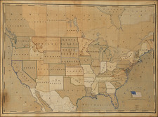
Handsome and exceedingly rare Carrington Bowles four-sheet map of the United States, Canada, Mexico, and the Caribbean published in London in 1784.
This is one of the earliest maps to name the United States and one of the first to show the American Flag.
A Very Early Appearance of the American Flag
The first map to illustrate the American Flag is Abel Buell's A New and Correct Map of the United States of North America Layd Down from the Latest Observations and Best Authorities Agreeable to the Peace of 1783, which sold for auction for $2,1 Million in 2011. As noted in the catalog description for the Buell map:
Buell advertised the just-completed map in the Connecticut Journal for March 31, 1784: "the first ever compiled, engraved, and finished by one man, and an American." Paul Cohen notes: "It should be pointed out that maps had been published in colonial America since 1677, but a new chapter in American cartography began after the formal establishment of the United States. After the Revolutionary War, new boundaries were determined, albeit imprecisely, at the Definitive Treaty of Peace, and proper maps of the country could then be published. Buell's was the first of the thirteen states to be published after the Congress of Confederation ratified the Treaty on January 14, 1784, but it was not the first to use the words 'United States,' as a few European publishers had employed them on maps before the ratification of the treaty." Connecticut was the first state to establish a copyright law and Buell's map is found in a 28 October 1783 petition to the Connecticut General Assembly. The copy at the New York Public Library does not contain the copyright information in the imprint and is therefore considered the first state. The remaining known copies, including the present, represent the second state, which in terms of its primacy of position as copyright holder gives it special consideration. . .
Within the large cartouche [of Buell's map] is found the FIRST FLAG OF THE UNITED STATES on a map printed in America. It carries thirteen stars, and is lit by the morning sun. Minerva, the Roman goddess of wisdom and war, blows her trumpet. Next to the title is Liberty, her staff supporting her liberty cap. "The globe in her hand shows the fledgling nation facing onward, and at Liberty's feet, the date of the first Independence Day is boldly engraved on a scroll" (Cohen).
Published April 12, 1784, Bowles's map was issued only days after the Buell's map was advertised and may, in fact, have been issued before the Buell map. The illustration of the flag is much more finely engraved and reflects the superior artisan skills available in the United Kingdom at the end of the 18th century.
The only earlier maps to depict the American Flag are Sebastian Bauman's ...[P]lan of the investment of York and Gloucester... and John Wallis's The United States of America laid down from the best authorities, agreeable to the Peace of 1783.
States
The present map is an unrecorded variant of Bowles's map of North America, first published in 1763, with an entirely new cartouche. The present example is noteworthy because it is one of the earliest printed maps to show the American Flag and includes an early depiction of Vermont, seven years before statehood.
The 1763 map was followed by editions of 1783, 1796, and 1808, each of which is virtually unobtainable.
The first edition of Carrington Bowles's spectacular map of North America, includes a different cartouche, with an early printing of the Treaty of Peace of 1763 below the cartouche. Following the Treaty of Peace in 1783, the map was revised, removing the Treaty of 1763 and revising the legend and scale of miles in the bottom right. In this 1784 variant edition, Article III of the Treaty of Peace is included, and an entirely new cartouche with an illustration of the American Flag is added.
Rarity
This is the second example of the map we have offered in the past 30 years. OCLC lists five examples (Library of Congress, British Natural History Museum, Penn State, University of Amsterdam & John Carter Brown). The present example is the only example to appear at auction in modern times. No examples are listed in AMPR.
![Johnson's North America [with Inset of Hawaii]](https://storage.googleapis.com/raremaps/img/small/88883.jpg)


![Trails: [1595-1945]: Land, Sea, and Air of The American Adventure Series](https://storage.googleapis.com/raremaps/img/small/70672.jpg)